File:13-09-29-nordfriesisches-wattenmeer-RalfR-05.jpg
Jump to navigation
Jump to search

Size of this preview: 800 × 347 pixels. Other resolutions: 320 × 139 pixels | 640 × 278 pixels | 1,024 × 444 pixels | 1,280 × 555 pixels | 4,145 × 1,798 pixels.
Original file (4,145 × 1,798 pixels, file size: 3.94 MB, MIME type: image/jpeg)
Summary
| Description |
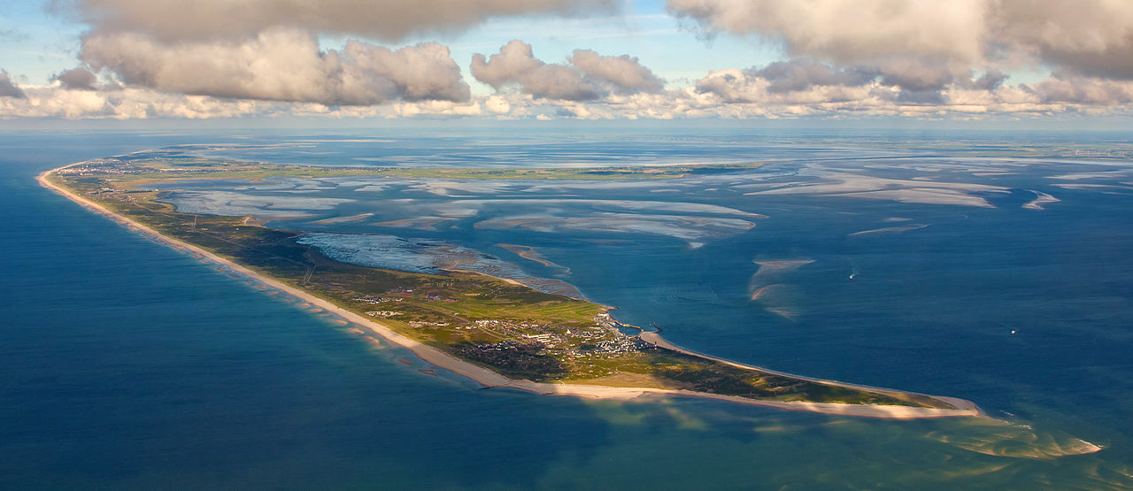
Čeština: Fotografie z letu nad Waddenzee u Severofríských ostrovů, pohled z jiho-jihozápadu (200 °), výška 1 km, vzdálenost 4 km od ostrova Sylt Deutsch: Fotoflug über das nordfriesische Wattenmeer, Blick aus SSW (200°), 1 km Höhe und 4 km Entfernung auf Sylt English: Photo flight over the North Frisian Wadden Sea, view from SSW (200 °), 1 km altitude and 4 km distance to Sylt Español: Foto vuelo sobre el Mar de Wadden de Frisia del Norte, vista desde el 1 kilometro de altura ya 4 km de Sylt Français : Vue aérienne des Îles frisonnes septentrionales du parc national de la mer des Wadden du Schleswig-Holstein. Vue à SSO (200 °), 1 km d'altitude et à 4 km de distance de Sylt. |
|||||||||||||||||||||||
| Date | ||||||||||||||||||||||||
| Source | Own work | |||||||||||||||||||||||
| Author |
|
|||||||||||||||||||||||
| Permission (Reusing this file) |
|
|||||||||||||||||||||||

| Camera location | | View this and other nearby images on: OpenStreetMap |
|---|
|
This image was selected as picture of the day on Wikimedia Commons for 29 March 2014. It was captioned as follows: English: Photo flight over the North Frisian Wadden Sea, view from SSW (200°), 1 km altitude and 4 km distance to Sylt Other languages:
Bosanski: Panoramski let iznad sjeverofrizijske obale u Njemačkoj, pogled sa jug-jugozapada sa visine 1km i udaljenosti 4km od ostrva Sylt Čeština: Letecký snímek ostrova Sylt ze skupiny Severofríských ostrovů, pohled z jiho-jihozápadu (SSW, 200 °) English: Photo flight over the North Frisian Wadden Sea, view from SSW (200°), 1 km altitude and 4 km distance to Sylt Italiano: Foto aerea delle Isole Frisone Settentrionali nel Mare dei Wadden, vista da SSW (200 °), da 1 km di altitudine e 4 km di distanza da Sylt Magyar: Légi fotó dél-délnyugat felől, 1 km magasból és 4 km távolságról Sylt szigetéről (Németország, Északi-Fríz-szigetek) Nederlands: Een vlucht over de Noord-Friese Waddeneilanden op een hoogte van 1000 meter en op vier kilometer afstand van het Duitse Waddeneiland Sylt. 中文: 北弗里西亚群岛俯拍照。 |
Licensing
I, the copyright holder of this work, hereby publish it under the following licenses:

|
Permission is granted to copy, distribute and/or modify this document under the terms of the GNU Free Documentation License, Version 1.2 or any later version published by the Free Software Foundation; with no Invariant Sections, no Front-Cover Texts, and no Back-Cover Texts. A copy of the license is included in the section entitled GNU Free Documentation License. |
This file is licensed under the Creative Commons Attribution-Share Alike 3.0 Unported, 2.5 Generic, 2.0 Generic and 1.0 Generic license.
- You are free:
- to share – to copy, distribute and transmit the work
- to remix – to adapt the work
- Under the following conditions:
- attribution – You must give appropriate credit, provide a link to the license, and indicate if changes were made. You may do so in any reasonable manner, but not in any way that suggests the licensor endorses you or your use.
- share alike – If you remix, transform, or build upon the material, you must distribute your contributions under the same or compatible license as the original.
You may select the license of your choice.

- Weiternutzung dieses Fotos
- Wenn Sie dieses Foto im Internet verwenden möchten, bitte ich um Verlinkung meiner privaten Homepage: www.fahrradmonteur.de.
Sie können das Bild unter einer der unten angegebenen Lizenzen frei verwenden, dabei ist keine Gebühr zu entrichten. Eine kommerzielle Verwendung dieses Fotos ist ebenfalls möglich, dabei sind außer den u. g. Lizenzbestimmungen keine gesonderten Bedingungen zu beachten.
| Dieses Foto entstand aufgrund eines Projektes, das von Wikimedia Deutschland e. V. gefördert wurde.
Im Rahmen des „Community-Projektbudgets“ sollen Luftbilder u.a. von Inseln, Halligen, Sanden und Küstenstädten der deutschen Nordseeküste angefertigt werden. Das Projekt „Fotoflüge“ wurde im September 2011 begonnen. |
| Annotations | This image is annotated: View the annotations at Commons |
File history
Click on a date/time to view the file as it appeared at that time.
| Date/Time | Thumbnail | Dimensions | User | Comment | |
|---|---|---|---|---|---|
| current | 12:37, 4 November 2013 | | 4,145 × 1,798 (3.94 MB) | wikimediacommons>Ralf Roletschek | {{Information |Description= |Source= |Date= |Author= |Permission= |other_versions= }} |
File usage
The following 3 pages use this file: