File:1st-SOUSE-sensors.png
Jump to navigation
Jump to search
No higher resolution available.
1st-SOUSE-sensors.png (300 × 280 pixels, file size: 155 KB, MIME type: image/png)
Summary
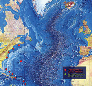
| Description |
English: The first SOSUS stations – NAVFACs – were sited from Barbados to Nova Scotia on a huge semi-circle that opened onto the deepwater abyss west of the Mid-Atlantic Ridge. Later, additional Atlantic-area stations were established at Argentia, Newfoundland, Keflavik, Iceland, and Brawdy, Wales.
Polski: Pierwsze stacje Sound Surveillance System - NAVFAC rozmieszczone pomiędzy barbados i Nową Szkocją w wielkim półkolu wzdłuz wschodniego wybrzeża USA. Dodatkowe stacje rozmieszczone były miedzy Nową Fundlandią, Islandią i Walią |
| Source | http://www.navy.mil/navydata/cno/n87/usw/issue_25/sosus.htm (archived source) |
| Author | Edward C. Whitman/US Navy |
Licensing
This file is a work of a sailor or employee of the U.S. Navy, taken or made as part of that person's official duties. As a work of the U.S. federal government, it is in the public domain in the United States.
|
 | |
| This file has been identified as being free of known restrictions under copyright law, including all related and neighboring rights. | ||
File history
Click on a date/time to view the file as it appeared at that time.
| Date/Time | Thumbnail | Dimensions | User | Comment | |
|---|---|---|---|---|---|
| current | 00:51, 5 August 2008 | | 300 × 280 (155 KB) | wikimediacommons>Matrek | {{Information |Description={{en|1=The first SOSUS stations – NAVFACs – were sited from Barbados to Nova Scotia on a huge semi-circle that opened onto the deepwater abyss west of the Mid-Atlantic Ridge. Later, additional Atlantic-area stations were est |
File usage
The following page uses this file: