File:AlbaniaTraditionalCommunitiesByLanguageAndReligion.png
Jump to navigation
Jump to search

Size of this preview: 461 × 599 pixels. Other resolutions: 184 × 240 pixels | 540 × 702 pixels.
Original file (540 × 702 pixels, file size: 26 KB, MIME type: image/png)
Summary
| Description |
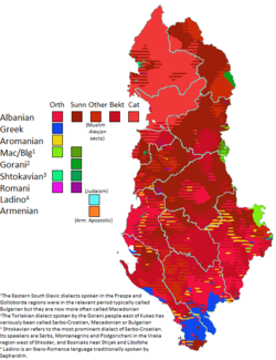
English: This map, using a wide variety of sources (available in a chart for where they apply), charts the traditional locations of notable linguistic and religious communities in Albania, around the early 20th century. Note that hatched areas imply the presence of multiple groups, but they do not imply parity-- in fact usually there is not parity. Thus this map underrepresents the demographic weight of local majorities -- such as Sunnis in Elbasan who are in a hatched area with Orthodox who they vastly outnumber. Thus in different areas, Sunni Albanians, Bektashi Albanians, Orthodox Albanians, Catholic Albanians, and Orthodox Greeks are likely underrepresented, while smaller groups (Vlachs, Sephardim, Roma) may be overrepresented where they occur. The citation chart for this map is can be found here (currently under construction still). If you do choose to edit this file, please edit this page as well so I know which sources you used. You may also use this page to request edits to the file, by presenting a source and saying where it pertains to, below the chart. |
| Date | |
| Source | Own work |
| Author | Calthinus |
Licensing
I, the copyright holder of this work, hereby publish it under the following license:
This file is licensed under the Creative Commons Attribution-Share Alike 4.0 International license.
- You are free:
- to share – to copy, distribute and transmit the work
- to remix – to adapt the work
- Under the following conditions:
- attribution – You must give appropriate credit, provide a link to the license, and indicate if changes were made. You may do so in any reasonable manner, but not in any way that suggests the licensor endorses you or your use.
- share alike – If you remix, transform, or build upon the material, you must distribute your contributions under the same or compatible license as the original.
File history
Click on a date/time to view the file as it appeared at that time.
| Date/Time | Thumbnail | Dimensions | User | Comment | |
|---|---|---|---|---|---|
| current | 05:37, 5 November 2021 | | 540 × 702 (26 KB) | wikimediacommons>User-duck | Cropped narrower using CropTool with lossless mode. |
File usage
The following 2 pages use this file: