File:AntwerpenGemeenten.png

From Vero - Wikipedia
Jump to navigation Jump to search

AntwerpenGemeenten.png (270 × 203 pixels, file size: 9 KB, MIME type: image/png)

This file is from Wikimedia Commons and may be used by other projects. The description on its file description page there is shown below.

File:Municipalities Antwerp Belgium Map - Number.svg is a vector version of this file. It should be used in place of this PNG file when not inferior.


For more information, see Help:SVG.

In other languages
Alemannisch  العربية  беларуская (тарашкевіца)  български  বাংলা  català  нохчийн  čeština  dansk  Deutsch  Ελληνικά  English  British English  Esperanto  español  eesti  euskara  فارسی  suomi  français  Frysk  galego  Alemannisch  עברית  हिन्दी  hrvatski  magyar  հայերեն  Bahasa Indonesia  Ido  italiano  日本語  ქართული  한국어  lietuvių  македонски  മലയാളം  Bahasa Melayu  မြန်မာဘာသာ  norsk bokmål  Plattdüütsch  Nederlands  norsk nynorsk  norsk  occitan  polski  prūsiskan  português  português do Brasil  română  русский  sicilianu  Scots  slovenčina  slovenščina  српски / srpski  svenska  தமிழ்  ไทย  Türkçe  татарча / tatarça  українська  vèneto  Tiếng Việt  中文  中文(中国大陆)  中文(简体)  中文(繁體)  中文(马来西亚)  中文(新加坡)  中文(臺灣)  +/−
New SVG image


This work has been released into the public domain by its author, LennartBolks, at the English Wikipedia project. This applies worldwide.

In case this is not legally possible:
LennartBolks grants anyone the right to use this work for any purpose, without any conditions, unless such conditions are required by law.

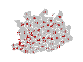
De 70 Antwerpse gemeenten en steden:

1. Aartselaar
2. Antwerpen
3. Arendonk
4. Baarle-Hertog
5. Balen
6. Beerse
7. Berlaar
8. Boechout
9. Bonheiden
10. Boom
11. Bornem
12. Borsbeek
13. Brasschaat
14. Brecht
15. Dessel
16. Duffel
17. Edegem
18. Essen
19. Geel
20. Grobbendonk
21. Heist-op-den-Berg
22. Hemiksem
23. Herentals
24. Herenthout
25. Herselt
26. Hoogstraten
27. Hove
28. Hulshout
29. Kalmthout
30. Kapellen
31. Kasterlee
32. Kontich
33. Laakdal
34. Lier
35. Lille

36. Lint
37. Malle
38. Mechelen
39. Meerhout
40. Merksplas
41. Mol
42. Mortsel
43. Niel
44. Nijlen
45. Olen
46. Oud-Turnhout
47. Putte
48. Puurs
49. Ranst
50. Ravels
51. Retie
52. Rijkevorsel
53. Rumst
54. Schelle
55. Schilde
56. Schoten
57. Sint-Amands
58. Sint-Katelijne-Waver
59. Stabroek
60. Turnhout
61. Vorselaar
62. Vosselaar
63. Westerlo
64. Wijnegem
65. Willebroek
66. Wommelgem
67. Wuustwezel
68. Zandhoven
69. Zoersel
70. Zwijndrecht

Captions

The 70 municipalities in Antwerp, prior to mergers reducing the total to 69 on 1 January 2019

Items portrayed in this file

depicts

image/png

fa27f6544f4f96d95bec14d1b6166f4c62043eb7

9,540 byte

203 pixel

270 pixel

File history

Click on a date/time to view the file as it appeared at that time.

Date/TimeThumbnailDimensionsUserComment
current17:32, 13 December 2004Thumbnail for version as of 17:32, 13 December 2004270 × 203 (9 KB)wikimediacommons>Walter{{PD}}

The following page uses this file: