File:BigSandy watershed.png
Jump to navigation
Jump to search
No higher resolution available.
BigSandy_watershed.png (288 × 240 pixels, file size: 70 KB, MIME type: image/png)
Summary
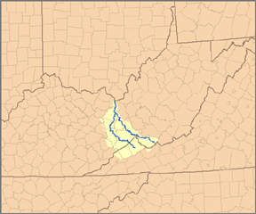
| Description | This is a map of the Big Sandy River system, showing its main tributaries, Tug Fork to the east and Levisa Fork to the west. I, Pfly, created it based on USGS data. |
| Date | |
| Source | Own work |
| Author | Pfly |
| Other versions | File:Bigsandyrivermap.png |
Licensing
I, the copyright holder of this work, hereby publish it under the following license:
This file is licensed under the Creative Commons Attribution-Share Alike 2.5 Generic license.
- You are free:
- to share – to copy, distribute and transmit the work
- to remix – to adapt the work
- Under the following conditions:
- attribution – You must give appropriate credit, provide a link to the license, and indicate if changes were made. You may do so in any reasonable manner, but not in any way that suggests the licensor endorses you or your use.
- share alike – If you remix, transform, or build upon the material, you must distribute your contributions under the same or compatible license as the original.
File history
Click on a date/time to view the file as it appeared at that time.
| Date/Time | Thumbnail | Dimensions | User | Comment | |
|---|---|---|---|---|---|
| current | 01:34, 24 March 2007 | | 288 × 240 (70 KB) | wikimediacommons>DanMS | Removed excess white space around edges and uploaded again. |
File usage
The following page uses this file: