File:Boswash.png
Jump to navigation
Jump to search

Size of this preview: 449 × 599 pixels. Other resolutions: 180 × 240 pixels | 360 × 480 pixels | 576 × 768 pixels | 768 × 1,024 pixels | 2,000 × 2,667 pixels.
Original file (2,000 × 2,667 pixels, file size: 1.81 MB, MIME type: image/png)
Summary
| Description |
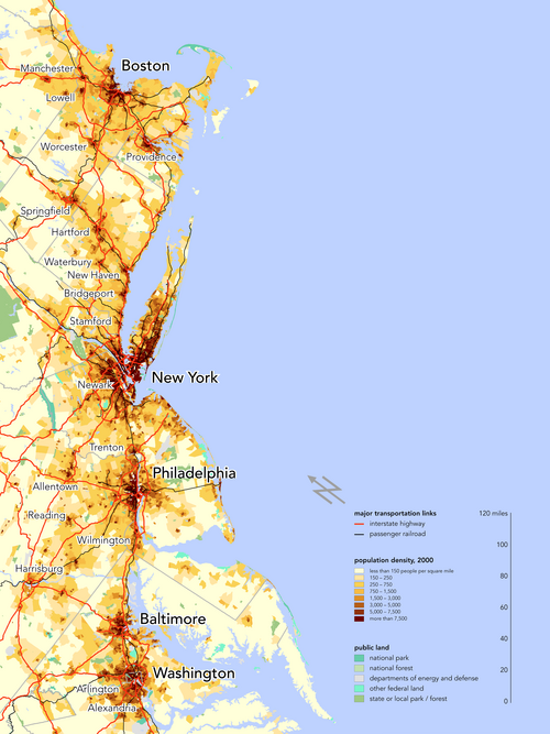
English: Population-density map of the Northeast megalopolis, also knows as Boston–Washington megalopolis or BosWash. |
| Date | |
| Source | Own work |
| Author | Bill Rankin — Citynoise (talk · contribs) |
| Permission (Reusing this file) |
|
Licensing
I, the copyright holder of this work, hereby publish it under the following license:
This file is licensed under the Creative Commons Attribution-Share Alike 3.0 Unported license.
- You are free:
- to share – to copy, distribute and transmit the work
- to remix – to adapt the work
- Under the following conditions:
- attribution – You must give appropriate credit, provide a link to the license, and indicate if changes were made. You may do so in any reasonable manner, but not in any way that suggests the licensor endorses you or your use.
- share alike – If you remix, transform, or build upon the material, you must distribute your contributions under the same or compatible license as the original.
File history
Click on a date/time to view the file as it appeared at that time.
| Date/Time | Thumbnail | Dimensions | User | Comment | |
|---|---|---|---|---|---|
| current | 21:35, 23 October 2022 | | 2,000 × 2,667 (1.81 MB) | wikimediacommons>Daniel FR | added north pointer, no further alterations |
File usage
The following page uses this file: