File:Bounty Voyages Map.png
Jump to navigation
Jump to search
Size of this preview: 800 × 583 pixels. Other resolutions: 320 × 233 pixels | 640 × 467 pixels | 934 × 681 pixels.
Original file (934 × 681 pixels, file size: 37 KB, MIME type: image/png)

|
This map image could be re-created using vector graphics as an SVG file. This has several advantages; see Commons:Media for cleanup for more information. If an SVG form of this image is available, please upload it and afterwards replace this template with
{{vector version available|new image name}}.It is recommended to name the SVG file “Bounty Voyages Map.svg”—then the template Vector version available (or Vva) does not need the new image name parameter. |
Summary
| Description |
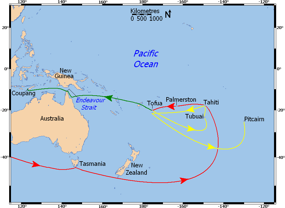
Deutsch: Karte der Reiseroute der Bounty. Rot: Reiseroute vor der Meuterei, gelb: Route der Bounty nach der Meuterei. grün: Fahrt der Barkassse unter Kapitän Bligh. Einige der kleinen Inseln sind nicht maßstabsgetreu wiedergegeben.
English: Labeled map of the voyages of HMS Bounty in the south Pacific: voyage prior to mutiny is red, voyage of Bounty after mutiny is yellow, voyage of Bligh and others in the longboat is green. Five labeled small islands enlarged for visibility (not to scale).
Français : Carte montrant la navigation du navire HMS Bounty dans l'océan Pacifique de 1788 à 1790 :
|
| Date | |
| Source |
Own work using:
|
| Author | Ruhrfisch (talk) |
| Permission (Reusing this file) |
GFDL, CC-BY-SA |
| Other versions |
No labels - base map  |
Licensing
I, the copyright holder of this work, hereby publish it under the following licenses:

|
Permission is granted to copy, distribute and/or modify this document under the terms of the GNU Free Documentation License, Version 1.2 or any later version published by the Free Software Foundation; with no Invariant Sections, no Front-Cover Texts, and no Back-Cover Texts. A copy of the license is included in the section entitled GNU Free Documentation License. |
This file is licensed under the Creative Commons Attribution-Share Alike 4.0 International, 3.0 Unported, 2.5 Generic, 2.0 Generic and 1.0 Generic license.
- You are free:
- to share – to copy, distribute and transmit the work
- to remix – to adapt the work
- Under the following conditions:
- attribution – You must give appropriate credit, provide a link to the license, and indicate if changes were made. You may do so in any reasonable manner, but not in any way that suggests the licensor endorses you or your use.
- share alike – If you remix, transform, or build upon the material, you must distribute your contributions under the same or compatible license as the original.
You may select the license of your choice.
File history
Click on a date/time to view the file as it appeared at that time.
| Date/Time | Thumbnail | Dimensions | User | Comment | |
|---|---|---|---|---|---|
| current | 13:11, 29 December 2009 | | 934 × 681 (37 KB) | wikimediacommons>Ruhrfisch | Moved Pacific Ocean label and enlarged it, removed Tongatabu label, enlarged labeled small islands for visibility, moved red line below Australia to enter map about 40 degrees south. |
File usage
The following 2 pages use this file: