File:Bozcaada map 1.jpg
Jump to navigation
Jump to search
No higher resolution available.
Bozcaada_map_1.jpg (284 × 248 pixels, file size: 18 KB, MIME type: image/jpeg)
Summary
| Description |
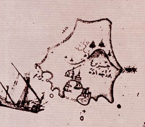
English: The map was drawn by Ottoman cartographer Piri Reis during 16th century. I've found it in an Italian web site: http://www.capurromrc.it/mappe/!011594darda.html
It is flipped for correct orientation and cropped to show the island alone. Filanca 11:46, 10 December 2006 (UTC) |
||||||||||||||||||||
| Source | Piri Reis | ||||||||||||||||||||
| Author |
|
||||||||||||||||||||

Licensing
|
This is a faithful photographic reproduction of a two-dimensional, public domain work of art. The work of art itself is in the public domain for the following reason:
The official position taken by the Wikimedia Foundation is that "faithful reproductions of two-dimensional public domain works of art are public domain".
This photographic reproduction is therefore also considered to be in the public domain in the United States. In other jurisdictions, re-use of this content may be restricted; see Reuse of PD-Art photographs for details. | ||||
Original upload log
The original description page was here. All following user names refer to en.wikipedia.
| Date/Time | Dimensions | User | Comment |
|---|---|---|---|
| 2006-12-10 11:46 | 284×248× (18802 bytes) | Filanca | The map was drawn by Ottoman cartographer Piri Reis during 16th century. I've found it in an italian web site: http://www.capurromrc.it/mappe/!011594darda.html It is flipped for correct orientation and cropped to show the island alone. ~~~~ |
File history
Click on a date/time to view the file as it appeared at that time.
| Date/Time | Thumbnail | Dimensions | User | Comment | |
|---|---|---|---|---|---|
| current | 07:31, 5 May 2015 | | 284 × 248 (18 KB) | wikimediacommons>Saintali | Transferred from en.wikipedia |
File usage
The following page uses this file: