File:Brayton railway station 1891390 2e9eaec4.jpg
Jump to navigation
Jump to search
No higher resolution available.
Brayton_railway_station_1891390_2e9eaec4.jpg (640 × 337 pixels, file size: 72 KB, MIME type: image/jpeg)
Summary
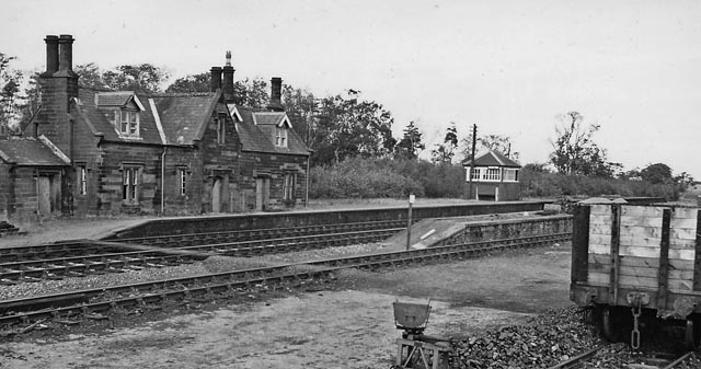
| Description |
English: Brayton Station (remains). View NE, towards Carlisle (and former junction with SJR); ex-Maryport & Carlisle main line and junction with Solway Junction Railway (SJR). Brayton station closed to passengers on 5/6/50, to goods 27/9/65. The southern portion of the SJR from Brayton to Annan over the Solway Viaduct had been closed in 9/21. See also NY2162 : Bowness-on-Solway Station (converted). Note the rather striking architecture - and it seems that after 11 years the station here was 'privatised'. |
| Date | |
| Source | From geograph.org.uk |
| Author | Ben Brooksbank |
| Permission (Reusing this file) |
Creative Commons Attribution Share-alike license 2.0 |
| Attribution (required by the license) | Ben Brooksbank / Brayton Station (remains) / |
| Camera location | | View this and other nearby images on: OpenStreetMap |
|---|
Licensing

|
This image was taken from the Geograph project collection. See this photograph's page on the Geograph website for the photographer's contact details. The copyright on this image is owned by Ben Brooksbank and is licensed for reuse under the Creative Commons Attribution-ShareAlike 2.0 license.
|
This file is licensed under the Creative Commons Attribution-Share Alike 2.0 Generic license.
Attribution:
Ben Brooksbank
- You are free:
- to share – to copy, distribute and transmit the work
- to remix – to adapt the work
- Under the following conditions:
- attribution – You must give appropriate credit, provide a link to the license, and indicate if changes were made. You may do so in any reasonable manner, but not in any way that suggests the licensor endorses you or your use.
- share alike – If you remix, transform, or build upon the material, you must distribute your contributions under the same or compatible license as the original.
File history
Click on a date/time to view the file as it appeared at that time.
| Date/Time | Thumbnail | Dimensions | User | Comment | |
|---|---|---|---|---|---|
| current | 15:52, 20 November 2010 | | 640 × 337 (72 KB) | wikimediacommons>Chevin | == {{int:filedesc}} == {{Information |Description={{en|1=Brayton Station (remains) View NE, towards Carlisle (and former junction with SJR); ex-Maryport & Carlisle main line and junction with Solway Junction Railway (SJR). Brayton station closed to passen |
File usage
The following page uses this file: