File:Cameroon boundary changes.PNG
Jump to navigation
Jump to search
Size of this preview: 710 × 600 pixels. Other resolutions: 284 × 240 pixels | 568 × 480 pixels | 910 × 768 pixels | 1,213 × 1,024 pixels | 2,000 × 1,689 pixels.
Original file (2,000 × 1,689 pixels, file size: 170 KB, MIME type: image/png)

|
This map image could be re-created using vector graphics as an SVG file. This has several advantages; see Commons:Media for cleanup for more information. If an SVG form of this image is available, please upload it and afterwards replace this template with
{{vector version available|new image name}}.It is recommended to name the SVG file “Cameroon boundary changes.svg”—then the template Vector version available (or Vva) does not need the new image name parameter. |
Summary
| Description |
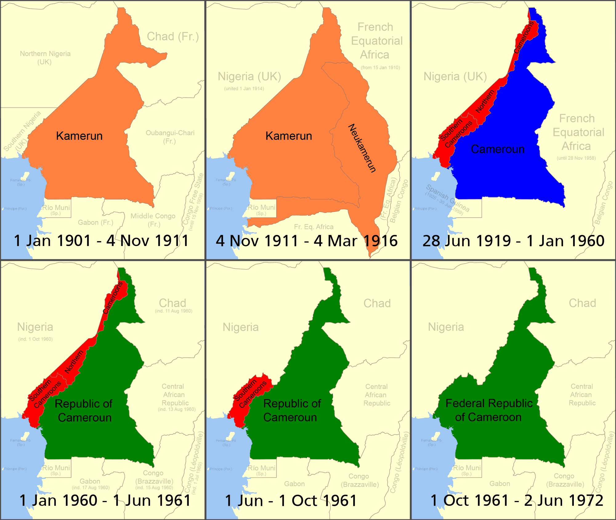
Deutsch: Änderung des Grenzverlaufs von Kamerun
English: Boundary changes in Cameroon (English)
Français : Évolution des frontières du Cameroun entre 1901 et 1972 (anglais)
Italiano: Evoluzione delle frontiere del Camerun tra il 1901 ed il 1972
Português: Mudança na fronteira dos Camarões
Deutsch: Die deutsche Kolonie Kamerun
English: German colony of Kamerun
Français : Colonie allemande du Cameroun
Italiano: Camerun tedesco
Deutsch: Cameroons
English: British Cameroons
Français : Cameroun britannique
Italiano: Camerun britannico
Deutsch: Französisch-Kamerun
English: French Cameroun
Français : Cameroun français
Italiano: Camerun francese
Deutsch: Unabhängiges Kamerun
English: Independent Cameroon
Français : Cameroun indépendant
Italiano: Camerun indipendente |
| Date | |
| Source | Self-made based on public domain CIA map Image:Cameroon Map.jpg, original svg file located here. |
| Author | Roke |
| Other versions |
|


|
File:Cameroon boundary changes-fr.svg is a vector version of this file. It should be used in place of this PNG file when not inferior.
File:Cameroon boundary changes.PNG → File:Cameroon boundary changes-fr.svg
For more information, see Help:SVG. |
 |
Reference
- German Cameroons 1914 archive copy at the Wayback Machine
- World Statesman, Cameroon
- Image:Southern cameroons.PNG - map of southern cameroons
- cameroon
- Kamerun 1912 archive copy at the Wayback Machine
- British Cameroons
Licensing
I, the copyright holder of this work, hereby publish it under the following licenses:

|
Permission is granted to copy, distribute and/or modify this document under the terms of the GNU Free Documentation License, Version 1.2 or any later version published by the Free Software Foundation; with no Invariant Sections, no Front-Cover Texts, and no Back-Cover Texts. A copy of the license is included in the section entitled GNU Free Documentation License. |
| This file is licensed under the Creative Commons Attribution-Share Alike 3.0 Unported license. | ||
| ||
| This licensing tag was added to this file as part of the GFDL licensing update. |
This file is licensed under the Creative Commons Attribution-Share Alike 2.5 Generic, 2.0 Generic and 1.0 Generic license.
- You are free:
- to share – to copy, distribute and transmit the work
- to remix – to adapt the work
- Under the following conditions:
- attribution – You must give appropriate credit, provide a link to the license, and indicate if changes were made. You may do so in any reasonable manner, but not in any way that suggests the licensor endorses you or your use.
- share alike – If you remix, transform, or build upon the material, you must distribute your contributions under the same or compatible license as the original.
You may select the license of your choice.
File history
Click on a date/time to view the file as it appeared at that time.
| Date/Time | Thumbnail | Dimensions | User | Comment | |
|---|---|---|---|---|---|
| current | 11:54, 18 July 2007 | | 2,000 × 1,689 (170 KB) | wikimediacommons>Roke~commonswiki | more detailed |
File usage
The following 4 pages use this file: