File:Canada four corners map closeup - en.svg
Jump to navigation
Jump to search

Size of this PNG preview of this SVG file: 600 × 600 pixels. Other resolutions: 240 × 240 pixels | 480 × 480 pixels | 768 × 768 pixels | 1,024 × 1,024 pixels | 2,048 × 2,048 pixels | 1,000 × 1,000 pixels.
Original file (SVG file, nominally 1,000 × 1,000 pixels, file size: 10 KB)
Summary
| Description |
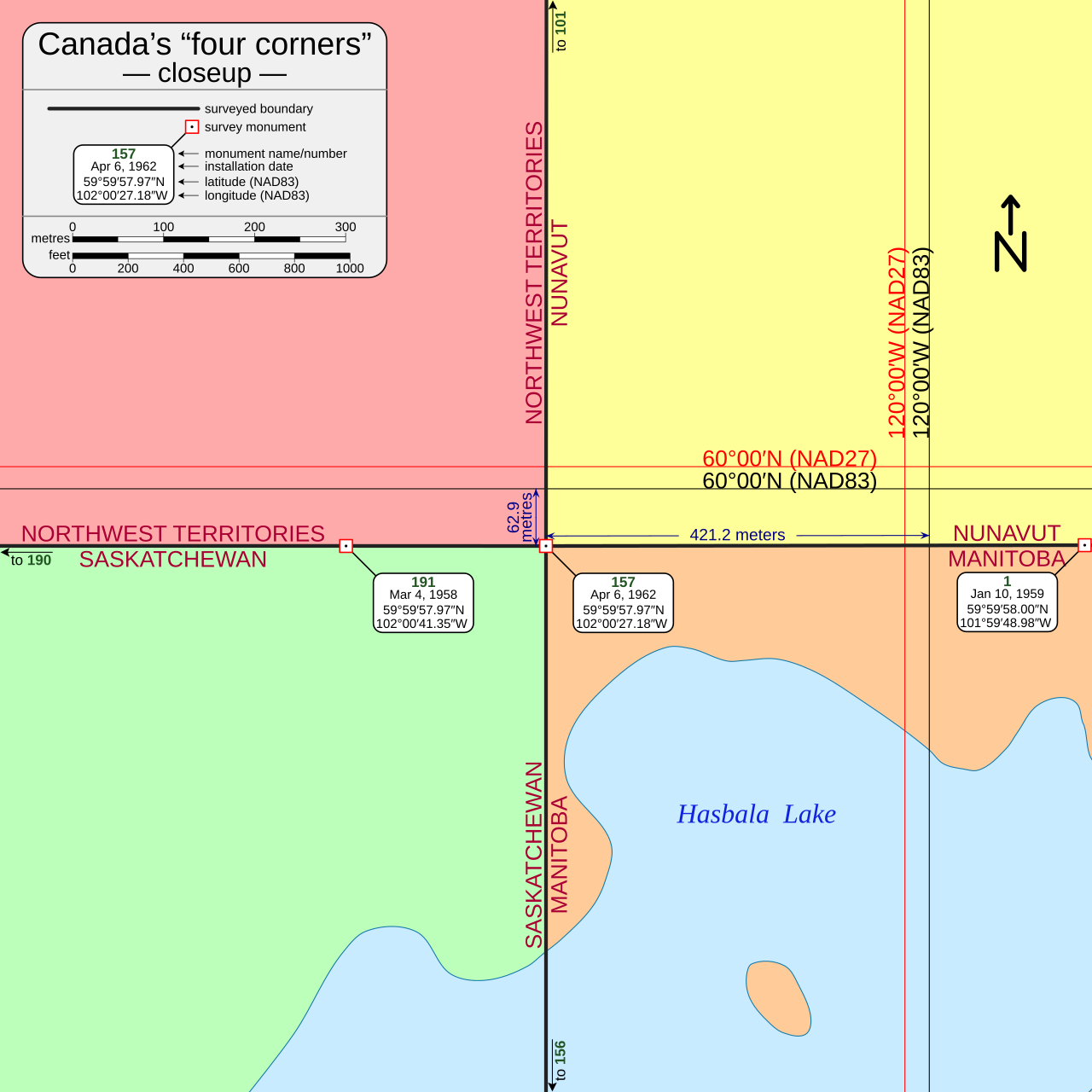
English: Map depicting all surveyed boundary lines and all survey monuments within a 600 metre radius of Canada's four corners.
Included on the map are two distances:
The two distances are calculated in UTM space and then scaled with the appropriate combined scale factor. The two distances only apply to Monument 157 and not to the boundary lines or other monuments. To be clear, the boundary lines are not parallel to the meridians or parallels even though they may appear to be parallel over short distances. |
| Date | |
| Source |
Own work based on data from:
|
| Author | MapGrid |
| Other versions |
|
| SVG development |


Licensing
I, the copyright holder of this work, hereby publish it under the following license:
This file is licensed under the Creative Commons Attribution-Share Alike 4.0 International license.
- You are free:
- to share – to copy, distribute and transmit the work
- to remix – to adapt the work
- Under the following conditions:
- attribution – You must give appropriate credit, provide a link to the license, and indicate if changes were made. You may do so in any reasonable manner, but not in any way that suggests the licensor endorses you or your use.
- share alike – If you remix, transform, or build upon the material, you must distribute your contributions under the same or compatible license as the original.
File history
Click on a date/time to view the file as it appeared at that time.
| Date/Time | Thumbnail | Dimensions | User | Comment | |
|---|---|---|---|---|---|
| current | 02:36, 9 March 2025 | | 1,000 × 1,000 (10 KB) | wikimediacommons>Tim Parenti | fix meridian typos 120°00′W → 102°00′W |
File usage
The following page uses this file: