File:Corfe Castle 1856 OS map.png
Jump to navigation
Jump to search
No higher resolution available.
Corfe_Castle_1856_OS_map.png (384 × 384 pixels, file size: 250 KB, MIME type: image/png)
| Description |
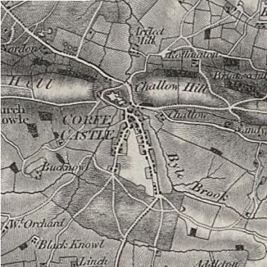
OS map of Corfe Castle in 1856. Scale 1:63360 (ie: one inch to one mile) |
|||||||||
| Date | ||||||||||
| Source | Ordnance Survey First Series, sheet 16. Published by the Ordnance Survey of Great Britain in 1856, hosted by Vision of Britain | |||||||||
| Creator |
Ordnance Survey of Great Britain |
|||||||||
| Geotemporal data | ||||||||||
| Bounding box |
|
|||||||||
| Georeferencing | ||||||||||
This work is an Ordnance Survey map over 50 years old, which is covered by Crown Copyright which in this case expires 50 years after publication. Ordnance Survey does however ask that they be credited and that the date of publication be given.
Any ancillary rights gained through the creation of the electronic version are granted as freely usable under any circumstances.
|
This work created by the United Kingdom Government is in the public domain.
This is because it is one of the following:
HMSO has declared that the expiry of Crown Copyrights applies worldwide (ref: HMSO Email Reply)
|
 |
File history
Click on a date/time to view the file as it appeared at that time.
| Date/Time | Thumbnail | Dimensions | User | Comment | |
|---|---|---|---|---|---|
| current | 20:12, 14 December 2011 | | 384 × 384 (250 KB) | wikimediacommons>Nev1 | {{Information |Description=OS map of Corfe Castle in 1856. Scale 1:63360 (ie: one inch to one mile) |Source=Ordnance Survey First Series, sheet 16. Published by the Ordnance Survey of Great Britain in 1856, hosted by [http://visionofbritain.org.uk/iipmoov |
File usage
The following page uses this file: