File:CornwallKernowMappa.png
Jump to navigation
Jump to search
Size of this preview: 800 × 587 pixels. Other resolution: 320 × 235 pixels.
Original file (952 × 698 pixels, file size: 167 KB, MIME type: image/png)

|
File:CornwallKernowMappa.svg is a vector version of this file. It should be used in place of this PNG file when not inferior.
File:CornwallKernowMappa.png → File:CornwallKernowMappa.svg
For more information, see Help:SVG. |
 |
Summary
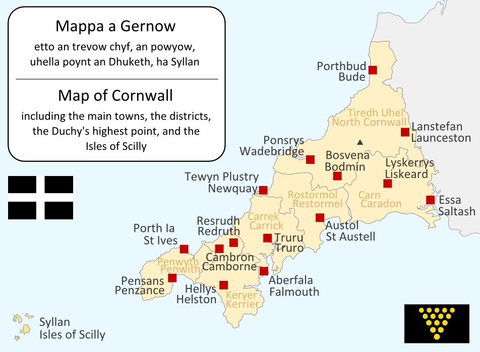
I made this map myself in September 2004. It is bilingual in Cornish and English, and shows the modern-day administrative boundaries of Cornwall and the larger towns. QuartierLatin1968 17:36, 14 Apr 2005 (UTC)

|
Permission is granted to copy, distribute and/or modify this document under the terms of the GNU Free Documentation License, Version 1.2 or any later version published by the Free Software Foundation; with no Invariant Sections, no Front-Cover Texts, and no Back-Cover Texts. A copy of the license is included in the section entitled GNU Free Documentation License. |
| This file is licensed under the Creative Commons Attribution-Share Alike 3.0 Unported license. | ||
| ||
| This licensing tag was added to this file as part of the GFDL licensing update. |

|
This locator map image could be re-created using vector graphics as an SVG file. This has several advantages; see Commons:Media for cleanup for more information. If an SVG form of this image is available, please upload it and afterwards replace this template with
{{vector version available|new image name}}.It is recommended to name the SVG file “CornwallKernowMappa.svg”—then the template Vector version available (or Vva) does not need the new image name parameter. |
| Annotations | This image is annotated: View the annotations at Commons |
File history
Click on a date/time to view the file as it appeared at that time.
| Date/Time | Thumbnail | Dimensions | User | Comment | |
|---|---|---|---|---|---|
| current | 19:09, 23 June 2011 | | 952 × 698 (167 KB) | wikimediacommons>Lader Gwiader | improve, SWF, place names from "A Concise Dictionary of Cornish Place Names" |
File usage
The following page uses this file: