File:Daedongyeojido-full.jpg
Jump to navigation
Jump to search

Size of this preview: 356 × 599 pixels. Other resolutions: 142 × 240 pixels | 285 × 480 pixels | 456 × 768 pixels | 609 × 1,024 pixels | 1,217 × 2,048 pixels | 17,837 × 30,000 pixels.
Original file (17,837 × 30,000 pixels, file size: 99.08 MB, MIME type: image/jpeg)
Summary
| Warning | The original file is very high-resolution. It might not load properly or could cause your browser to freeze when opened at full size. |
|---|
| Description |
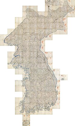
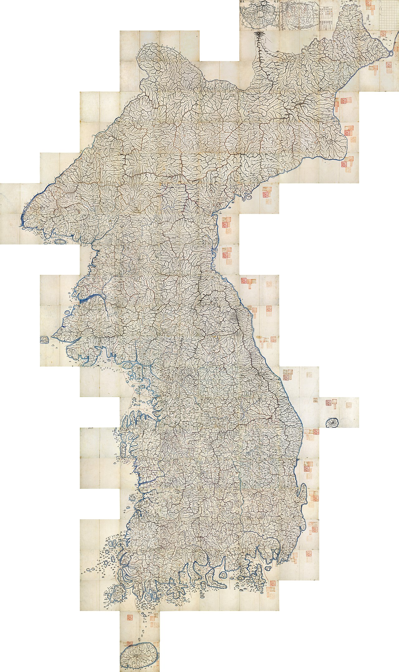
English: Daedongyeojido ("The Great Map of the East Land") is a full scale[clarification needed] map of Korea produced in 1861. Although no modern survey techniques were used, it is remarkably similar to modern maps. This marks the zenith of pre-modern Korean cartography; this file is the full mozaic version of it, which can be read just as easily as a Google interactive map. JPG(99 MB) mirror, PNG(618 MB) mirror. All three extant copies of the map are designated as secondary national treasures of South Korea; this one is treasure item number 850-3, which is owned by Seoul National University's Kyujanggak Institute for Korean Studies. Stamps on the map indicate its ownership (""서울 大學校 圖書" for "Seoul National University's book"; "朝鮮総督府圖書之印" for "stamp of Governor-General of Korea"; and "奎章閣韓國學圖書" for Kyujanggak Institute for Korean Studies. See discussion of stamps here.
한국어: 《대동여지도》(大東輿地圖)는 1861년에 김정호가 제작한 한국의 고지도이다. 근대적 측량 기술이 사용되지 않았으나, 그 세밀함이 근대의 지도에 필적한다. 전근대 한국 지도제작술의 정수라고 할 수 있다.
العربية: هذه الخريطة القديمة صنعها كم جونغ هو، وتعرف باسم دايدونغ يوجيدو وحرفياً "الخريطة العظمى للأراضي الشرقية" (بالكورية: 대동여지도) وتمثل أفضل أعمال كم. رسمت الخريطة في سنة 1861، في زمن مملكة جوسون. صنعت الخريطة باستخدام الأساليب الكورية والغربية، وتعتبر خريطة متقدمة بالنسبة لزمن صنعها. |
| Date | |
| Source | http://147.46.103.182/OIS/GZ2/VIEWER.jsp?maptype=DD001 |
| Creator | |
| Georeferencing | If inappropriate please set warp_status = skip to hide. |
| Other versions |

|
 |
|

_01-01.jpg)
_01-02.jpg)
_01-03.jpg)
_01-04.jpg)
_01-08.jpg)
_01-07.jpg)
_01-06.jpg)
_01-05.jpg)
_02-06.jpg)
_02-05.jpg)
_02-04.jpg)
_02-03.jpg)
_02-02.jpg)
_02-01.jpg)
_03-07.jpg)
_03-06.jpg)
_03-05.jpg)
_03-04.jpg)
_03-03.jpg)
_03-02.jpg)
_03-01.jpg)
_04-07.jpg)
_04-06.jpg)
_04-05.jpg)
_04-04.jpg)
_04-03.jpg)
_04-02.jpg)
_04-01.jpg)
_05-07.jpg)
_05-06.jpg)
_05-05.jpg)
_05-04.jpg)
_05-03.jpg)
_05-02.jpg)
_05-01.jpg)
_06-08.jpg)
_06-07.jpg)
_06-06.jpg)
_06-05.jpg)
_06-04.jpg)
_06-03.jpg)
_06-02.jpg)
_06-01.jpg)
_07-07.jpg)
_07-06.jpg)
_07-05.jpg)
_07-04.jpg)
_07-03.jpg)
_07-02.jpg)
_07-01.jpg)
_08-06.jpg)
_08-05.jpg)
_08-04.jpg)
_08-03.jpg)
_08-02.jpg)
_08-01.jpg)
_09-04.jpg)
_09-03.jpg)
_09-02.jpg)
_09-01.jpg)
_10-06.jpg)
_10-05.jpg)
_10-04.jpg)
_10-03.jpg)
_10-02.jpg)
_10-01.jpg)
_11-06.jpg)
_11-05.jpg)
_11-04.jpg)
_11-03.jpg)
_11-02.jpg)
_11-01.jpg)
_12-06.jpg)
_12-05.jpg)
_12-04.jpg)
_12-03.jpg)
_12-02.jpg)
_12-01.jpg)
_13-06.jpg)
_13-05.jpg)
_13-04.jpg)
_13-03.jpg)
_13-02.jpg)
_13-01.jpg)
_14-06.jpg)
_14-05.jpg)
_14-04.jpg)
_14-03.jpg)
_14-02.jpg)
_14-01.jpg)
_15-06.jpg)
_15-05.jpg)
_15-04.jpg)
_15-03.jpg)
_15-02.jpg)
_15-01.jpg)
_16-06.jpg)
_16-05.jpg)
_16-04.jpg)
_16-03.jpg)
_16-02.jpg)
_16-01.jpg)
_17-05.jpg)
_17-04.jpg)
_17-03.jpg)
_17-02.jpg)
_17-01.jpg)
_18-06.jpg)
_18-05.jpg)
_18-04.jpg)
_18-03.jpg)
_18-02.jpg)
_18-01.jpg)
_19-06.jpg)
_19-05.jpg)
_19-04.jpg)
_19-03.jpg)
_19-02.jpg)
_19-01.jpg)
_20-05.jpg)
_20-04.jpg)
_20-03.jpg)
_20-02.jpg)
_20-01.jpg)
_21-01.jpg)
_22-01.jpg)
This image was selected as picture of the day on Wikimedia Commons for 9 August 2013. It was captioned as follows: English: Daedongyeojido ("The Great Map of the East Land") is an old map of Korea, which was made in 1861. Although no modern survey skills were used for this map, it is almost similar to modern maps. Other languages:
Deutsch: Daedongyeojido ("Die große Karte des östlichen Landes") ist eine alte Karte von Korea aus dem Jahr 1861. Obwohl keine modernen Techniken zu ihrer Herstellung verwendet wurden, sind die Unterschiede zu heutigen Karten minimal. English: Daedongyeojido ("The Great Map of the East Land") is an old map of Korea, which was made in 1861. Although no modern survey skills were used for this map, it is almost similar to modern maps. Italiano: Daedongyeojido ("La grande mappa della Terra Orientale") è una vecchia mappa della Corea realizzata nel 1861. Sebbene non siano state usate le moderne tecniche topografiche per la sua realizzazione è molto simile alle mappe moderne. Magyar: Daedongyeojido ("A keleti ország nagy térképe") Korea 1861-ben készült térképe. Bár nem használtak hozzá modern felméréseket, a mai térképekkel közel azonos Nederlands: Daedongyeojido ("De grote kaart van het Oostland") is een oude kaart van Korea die gemaakt werd in 1861. Hoewel er geen moderne opmetingstechnieken werden toegepast voor de kaart, is deze sterk gelijkend ten opzichte van moderne kaarten. Русский: Карта Кореи 1861 года. 日本語: 『大東輿地図』(だいとうよちず)は、金正浩が1861年に完成した韓国の古地図である。近代的測量技術が使われなかったが、その細密さが近代の地図に匹敵する。 中文: 大東輿地圖,绘制于1861年,虽然没有运用现代的技术,但是已经很接近现代的地图。 |
Licensing
|
This is a faithful photographic reproduction of a two-dimensional, public domain work of art. The work of art itself is in the public domain for the following reason:
The official position taken by the Wikimedia Foundation is that "faithful reproductions of two-dimensional public domain works of art are public domain".
This photographic reproduction is therefore also considered to be in the public domain in the United States. In other jurisdictions, re-use of this content may be restricted; see Reuse of PD-Art photographs for details. | ||||
| Annotations | This image is annotated: View the annotations at Commons |
This image has been assessed using the Quality image guidelines and is considered a Quality image.
|
File history
Click on a date/time to view the file as it appeared at that time.
| Date/Time | Thumbnail | Dimensions | User | Comment | |
|---|---|---|---|---|---|
| current | 01:11, 5 February 2013 | | 17,837 × 30,000 (99.08 MB) | wikimediacommons>Salamander724 | non-progressive |
File usage
The following page uses this file: