File:DeSoto Map Leg 2 HRoe 2008.jpg
Jump to navigation
Jump to search
No higher resolution available.
DeSoto_Map_Leg_2_HRoe_2008.jpg (600 × 470 pixels, file size: 290 KB, MIME type: image/jpeg)
Summary
| Description |
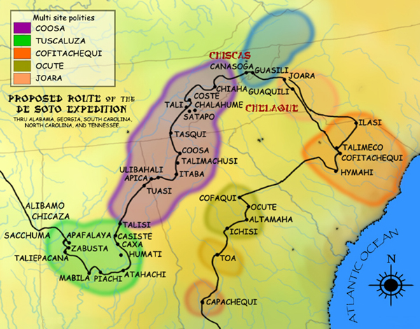
English: A map showing the de Soto expedition route through the future U.S. states of Georgia, South Carolina, North Carolina, Tennessee, and Alabama. Based on the Charles M. Hudson map of 1997. |
| Date |
20 September 2008 (original upload date) |
| Source | Own work (Original text: I created this work entirely by myself.) |
| Author | Heironymous Rowe (talk) |
Licensing
Heironymous Rowe at English Wikipedia, the copyright holder of this work, hereby publishes it under the following licenses:
This file is licensed under the Creative Commons Attribution-Share Alike 3.0 Unported license.
Attribution:
- You are free:
- to share – to copy, distribute and transmit the work
- to remix – to adapt the work
- Under the following conditions:
- attribution – You must give appropriate credit, provide a link to the license, and indicate if changes were made. You may do so in any reasonable manner, but not in any way that suggests the licensor endorses you or your use.
- share alike – If you remix, transform, or build upon the material, you must distribute your contributions under the same or compatible license as the original.

|
Permission is granted to copy, distribute and/or modify this document under the terms of the GNU Free Documentation License, Version 1.2 or any later version published by the Free Software Foundation; with no Invariant Sections, no Front-Cover Texts, and no Back-Cover Texts. A copy of the license is included in the section entitled GNU Free Documentation License. |
You may select the license of your choice.
Original upload log
Transferred from en.wikipedia to Commons by Dmitri Lytov using CommonsHelper.
The original description page was here. All following user names refer to en.wikipedia.
- 2008-09-20 02:14 Heironymous Rowe 610×480× (315397 bytes) {{Information |Description=A map showing the Hernando de Soto|de Soto]] expedition route thru [[Georgia]], [[South Carolina]], [[North Carolina]], [[Tennessee]], and [[Alabama]]. Based on the [[Charles M. Hudson (author)|Charles M. Hudson]] map of 1997. |
File history
Click on a date/time to view the file as it appeared at that time.
| Date/Time | Thumbnail | Dimensions | User | Comment | |
|---|---|---|---|---|---|
| current | 22:11, 22 June 2010 | | 600 × 470 (290 KB) | wikimediacommons>Ras67 | cropped, watermark removed |
File usage
The following page uses this file: