File:East Beirut canton.png
Jump to navigation
Jump to search

Size of this preview: 592 × 599 pixels. Other resolutions: 237 × 240 pixels | 474 × 480 pixels | 759 × 768 pixels | 1,012 × 1,024 pixels | 2,231 × 2,258 pixels.
Original file (2,231 × 2,258 pixels, file size: 35 KB, MIME type: image/png)
Summary
| Description |
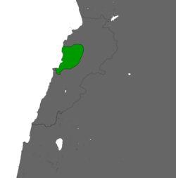
English: Map of the East Beirut canton (Marounistan) one of many militia controlled territories during the Lebanese Civil War |
| Date | |
| Source | File:Free Lebanon State.png |
| Author | DamiKarv |
Licensing
This file is licensed under the Creative Commons Attribution-Share Alike 4.0 International license.
- You are free:
- to share – to copy, distribute and transmit the work
- to remix – to adapt the work
- Under the following conditions:
- attribution – You must give appropriate credit, provide a link to the license, and indicate if changes were made. You may do so in any reasonable manner, but not in any way that suggests the licensor endorses you or your use.
- share alike – If you remix, transform, or build upon the material, you must distribute your contributions under the same or compatible license as the original.
File history
Click on a date/time to view the file as it appeared at that time.
| Date/Time | Thumbnail | Dimensions | User | Comment | |
|---|---|---|---|---|---|
| current | 15:21, 19 June 2022 | | 2,231 × 2,258 (35 KB) | wikimediacommons>Prodrummer619 | Uploaded a work by DamiKarv from File:Free Lebanon State.png with UploadWizard |
File usage
The following page uses this file: