File:European Union map.png
Jump to navigation
Jump to search
No higher resolution available.
European_Union_map.png (552 × 483 pixels, file size: 112 KB, MIME type: image/png)
Summary
| Description |
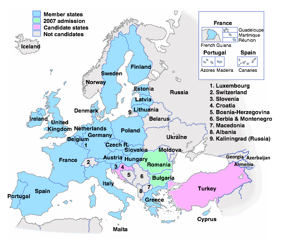
English: The European Union member states, 2007 admissions and candidate countries. Based on :Image:EU_blank_no_rivers_territories256.png and :Image:EU map names isles.png, both created by User:Zoney (see revision history of that page for earlier versions). |
| Date | 24 October 2004 (original upload date) |
| Source | Transferred from en.wikipedia to Commons. |
| Author | The original uploader was Gdr at English Wikipedia. |
Licensing
| This file is licensed under the Creative Commons Attribution-Share Alike 3.0 Unported license. Subject to disclaimers. | ||
| ||
| This licensing tag was added to this file as part of the GFDL licensing update. |

|
Permission is granted to copy, distribute and/or modify this document under the terms of the GNU Free Documentation License, Version 1.2 or any later version published by the Free Software Foundation; with no Invariant Sections, no Front-Cover Texts, and no Back-Cover Texts. A copy of the license is included in the section entitled GNU Free Documentation License. Subject to disclaimers. |
Original upload log
The original description page was here. All following user names refer to en.wikipedia.
| Date/Time | Dimensions | User | Comment |
|---|---|---|---|
| 2004-11-02 21:29 | 552×483× (72848 bytes) | Gdr | oops, uploaded wrong image last time |
| 2004-11-02 16:18 | 552×483× (72806 bytes) | Gdr | Make French Guiana look less like an island |
| 2004-11-02 01:00 | 552×480× (117410 bytes) | Gdr | More saturated colours |
| 2004-11-01 13:37 | 552×479× (117241 bytes) | Gdr | Colour Croatia as a candidate state |
| 2004-10-29 00:27 | 552×476× (70669 bytes) | Gdr | And compress a bit |
| 2004-10-29 00:26 | 552×476× (117213 bytes) | Gdr | Oops, uploaded wrong image last time! |
| 2004-10-28 21:35 | 552×475× (117450 bytes) | Gdr | Add legend for non candidate states |
| 2004-10-27 01:29 | 552×475× (117450 bytes) | Gdr | add Kaliningrad; improve lettering |
| 2004-10-24 17:54 | 551×475× (138589 bytes) | Gdr | The [[European Union]] member states, 2007 admissions and candidate country |
File history
Click on a date/time to view the file as it appeared at that time.
| Date/Time | Thumbnail | Dimensions | User | Comment | |
|---|---|---|---|---|---|
| current | 11:56, 22 September 2022 | | 552 × 483 (112 KB) | wikimediacommons>Рагин1987 | Small correction |
File usage
The following page uses this file: