File:French British Forts 1753 1758.png
Jump to navigation
Jump to search
No higher resolution available.
French_British_Forts_1753_1758.png (328 × 423 pixels, file size: 32 KB, MIME type: image/png)

|
This historical map image could be re-created using vector graphics as an SVG file. This has several advantages; see Commons:Media for cleanup for more information. If an SVG form of this image is available, please upload it and afterwards replace this template with
{{vector version available|new image name}}.It is recommended to name the SVG file “French British Forts 1753 1758.svg”—then the template Vector version available (or Vva) does not need the new image name parameter. |
Summary
| Description |
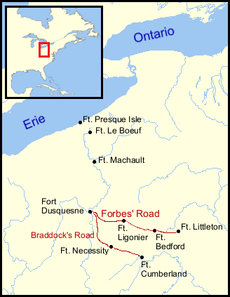
English: French and British forts built in the Ohio Country from 1753 to 1758. Includes French Forts (New France): Fort Presque Isle, Fort Le Boeuf, Fort Machault and Fort Duquesne. Also, British Forts: Fort Littleton, Fort Bedford, Fort Ligonier, Fort Necessity and Fort Cumberland. Shows positions of Lancaster, Pennsylvania, and Philadelphia, Pennsylvania. Also shows the approximate routes of Braddock's Road and Forbes Road. |
| Date | |
| Source | Positions determined by descriptions found in The Frontier Forts of Western Pennsylvania, Albert, George Dallas, C. M. Busch, state printer, Harrisburg, 1896, and other sources; Background map courtesy of Demis |
| Author | Thomas Cool |
| Other versions |
Derivative works of this file: |
Licensing
| I, the copyright holder of this work, release this work into the public domain. This applies worldwide. In some countries this may not be legally possible; if so: I grant anyone the right to use this work for any purpose, without any conditions, unless such conditions are required by law. |
This image is in the public domain because it came from the site https://www.demis.nl/products/web-map-server/examples/ and was released by the copyright holder. Permission is granted to copy, distribute and/or modify this map since it is based on free of copyright images from: www.demis.nl. See also approval email on de.wp and its clarification.
|
| This work has been released into the public domain by its copyright holder, www.demis.nl. This applies worldwide. In some countries this may not be legally possible; if so: www.demis.nl grants anyone the right to use this work for any purpose, without any conditions, unless such conditions are required by law.
|
File history
Click on a date/time to view the file as it appeared at that time.
| Date/Time | Thumbnail | Dimensions | User | Comment | |
|---|---|---|---|---|---|
| current | 21:46, 7 January 2007 | | 328 × 423 (32 KB) | wikimediacommons>Tomcool~commonswiki |
File usage
The following 3 pages use this file: