File:Front Range Urban Corridor.svg
Jump to navigation
Jump to search

Size of this PNG preview of this SVG file: 514 × 599 pixels. Other resolutions: 206 × 240 pixels | 412 × 480 pixels | 659 × 768 pixels | 878 × 1,024 pixels | 1,756 × 2,048 pixels | 723 × 843 pixels.
Original file (SVG file, nominally 723 × 843 pixels, file size: 265 KB)
Summary
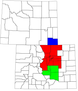
| Description | A county map of the Front Range Urban Corridor of Colorado and Wyoming, United States |
| Date | |
| Source | Derived from the National Atlas of the United States as converted by David Benbennick (CC) and adapted by Buaidh |
| Author | Buaidh |
| Permission (Reusing this file) |
This file is licensed under the Creative Commons Attribution 2.0 Generic license.
|
| Other versions | Map of Colorado counties, blank.svg and Map of Wyoming highlighting Laramie County.svg |
Licensing
| I, the copyright holder of this work, release this work into the public domain. This applies worldwide. In some countries this may not be legally possible; if so: I grant anyone the right to use this work for any purpose, without any conditions, unless such conditions are required by law. |
File history
Click on a date/time to view the file as it appeared at that time.
| Date/Time | Thumbnail | Dimensions | User | Comment | |
|---|---|---|---|---|---|
| current | 01:20, 12 December 2007 | | 723 × 843 (265 KB) | wikimediacommons>Buaidh | == Summary == {{Information |Description=A county map of the Front Range Urban Corridor of Colorado and Wyoming, United States |title=Map of the Front Range Urban Corridor |Source=Derived from the National Atlas of the United States as converted by David |
File usage
The following page uses this file: