File:Galbraith Rail Service Map1897.png
Jump to navigation
Jump to search
No higher resolution available.
Galbraith_Rail_Service_Map1897.png (457 × 327 pixels, file size: 339 KB, MIME type: image/png)
Summary
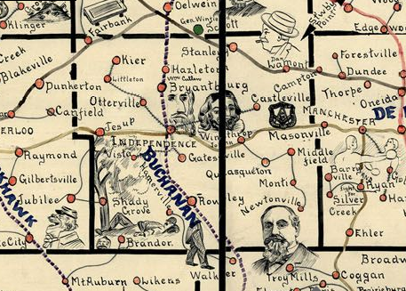
| Description | Detail of the Iowa Galbraith Rail Service Map of 1897, showing Buchanan County, Iowa. |
| Date | |
| Source | Galbraith Rail Service |
| Author | Frank H. Galbraith |
| Permission (Reusing this file) |
Public domain |
Licensing
This media file is in the public domain in the United States. This applies to U.S. works where the copyright has expired, often because its first publication occurred prior to January 1, 1930, and if not then due to lack of notice or renewal. See this page for further explanation.
|
 | |
 |
File history
Click on a date/time to view the file as it appeared at that time.
| Date/Time | Thumbnail | Dimensions | User | Comment | |
|---|---|---|---|---|---|
| current | 22:58, 13 January 2008 | | 457 × 327 (339 KB) | wikimediacommons>Firsfron | {{Information |Description=Detail of the Iowa Galbraith Rail Service Map of 1897, showing Buchanan County, Iowa. |Source=Galbraith Rail Service |Date=1897 |Author=Frank H. Galbraith |Permission=Public domain |other_versions= }} |
File usage
The following page uses this file: