File:HighwaysMapPoland.svg
Jump to navigation
Jump to search

Size of this PNG preview of this SVG file: 643 × 599 pixels. Other resolutions: 258 × 240 pixels | 515 × 480 pixels | 824 × 768 pixels | 1,099 × 1,024 pixels | 2,198 × 2,048 pixels | 776 × 723 pixels.
Original file (SVG file, nominally 776 × 723 pixels, file size: 364 KB)
Summary
| Description |
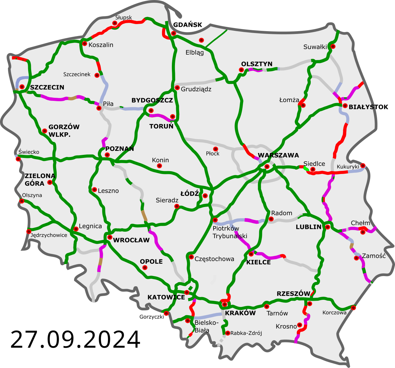
Polski: Polskie autostrady i drogi ekspresowe:
istniejące przejezdne (na zasadzie tymczasowej organizacji ruchu) w budowie umowa „projektuj i buduj”; etap projektowania w przetargu wydana decyzja środowiskowa planowane (linia przerywana – potencjalne) English: Polish freeways:
Completed Opened, some works continue Construction Design-build contract (design phase) Environmental permit issued Planned (dashed line – potential) Deutsch: polnische Autobahnen und Schnellstraßen:
fertiggestellt geöffnet, einige Arbeiten gehen weiter im Bau Entwurfs- und Bauvertrag, Entwurfsphase in der Ausschreibung Umweltverträglichkeitsprüfung geplant (gestrichelte Linie – Potenzial) Čeština: Polské dálnice a rychlostní silnice:
v provozu ve stavbě plánované (přerušovaná čára – potenciál) Esperanto: Polaj aŭtovojoj kaj rapidvojoj:
kompletigitaj malfermitaj, kelkaj laboroj daŭras konstruataj skizo kaj konstrukontrakto, projektfazo ofertataj al konstrufirmaoj planitaj (strekita linio - potencialo) Español: Autopistas y autovias polacas:
abiertas en construcción en proyecto (línea discontinua – potencial) Français : Les autoroutes polonaises:
Existantes Ouvert, certains travaux se poursuivent En construction Contrat de conception-construction (phase de conception) Appel d'offres Permis d’environnement délivré En projet (ligne pointillée - potentiel) Magyar: Lengyelország autópályái:
kész szakasz épülő szakasz tervezett szakasz (szaggatott vonal – potenciál) Italiano: Autostrade polacche: aperte al traffico aperte, con lavori in corso in costruzione appaltate, con costruzione in fase di progetto con gara di appalto avviata con valutazione di impatto ambientale emessa progettate (linea tratteggiata – potenziale) |
||
| Date | |||
| Source | |||
| Author |
|
||
| Other versions | Derivative works of this file: Historia budowy autostrad i dróg ekspresowych.gif | ||
| SVG development |
|
Licensing
I, the copyright holder of this work, hereby publish it under the following licenses:
This file is licensed under the Creative Commons Attribution 3.0 Unported license.
- You are free:
- to share – to copy, distribute and transmit the work
- to remix – to adapt the work
- Under the following conditions:
- attribution – You must give appropriate credit, provide a link to the license, and indicate if changes were made. You may do so in any reasonable manner, but not in any way that suggests the licensor endorses you or your use.
You may select the license of your choice.
Original upload log
This image is a derivative work of the following images:
- DocelowyUkladDrog.svg licensed with Cc-by-3.0, Cc-by-3.0
- 2009-08-30T16:41:32Z Sliwers 784x723 (155471 Bytes) Darker color.
- 2009-08-30T16:40:18Z Sliwers 784x723 (155471 Bytes) Cropped.
- 2009-08-30T16:36:58Z Sliwers 1073x790 (154212 Bytes) {{Information |Description={{en|1=Map of the planned free- and expressway network in Poland.}} {{pl|1=Docelowy układ autostrad i dróg ekspresowych w Polsce.}} {{de|1=Das Autobahn- und Schnellstraßennetz Polens, geplanter E
Uploaded with derivativeFX
File history
Click on a date/time to view the file as it appeared at that time.
| Date/Time | Thumbnail | Dimensions | User | Comment | |
|---|---|---|---|---|---|
| current | 21:25, 20 January 2026 | No thumbnail | 776 × 723 (364 KB) | wikimediacommons>Docxent | wydanie ZRID dla odcinka S10 Piecnik - Wałcz Zach. |
File usage
The following page uses this file: