File:Ivy Mike fallout map.png
Jump to navigation
Jump to search
Size of this preview: 601 × 599 pixels. Other resolutions: 241 × 240 pixels | 634 × 632 pixels.
Original file (634 × 632 pixels, file size: 52 KB, MIME type: image/png)
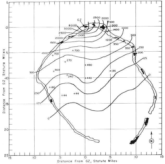
| Description | Fallout map showing radiation intensities (in rads/hour) an hour after the test. Note that this is showing upwind fallout only — no monitoring of downwind fallout was done during the Mike test. |
| Source | nuclearweaponarchive.org |
| Author | |
| Permission (Reusing this file) |
Copyright status: Created by the US Atomic Energy Commission, US government public domain. |
| This image is a work of a United States Department of Energy (or predecessor organization) employee, taken or made as part of that person's official duties. As a work of the U.S. federal government, the image is in the public domain.
Please note that national laboratories operate under varying licences and some are not free. Check the site policies of any national lab before crediting it with this tag.
|

|
File history
Click on a date/time to view the file as it appeared at that time.
| Date/Time | Thumbnail | Dimensions | User | Comment | |
|---|---|---|---|---|---|
| current | 11:11, 17 June 2007 | | 634 × 632 (52 KB) | wikimediacommons>Felix Stember | {{Information |Description=Fallout map showing radiation intensities (in rads/hour) an hour after the test |Source=[http://nuclearweaponarchive.org/Usa/Tests/Imikefallout.gif nuclearweaponarchive.org] |Date= |Author= |Permission=Copyright status: Created |
File usage
The following page uses this file: