File:Juba map.jpg
Jump to navigation
Jump to search
No higher resolution available.
Juba_map.jpg (519 × 533 pixels, file size: 67 KB, MIME type: image/jpeg)
| Description |
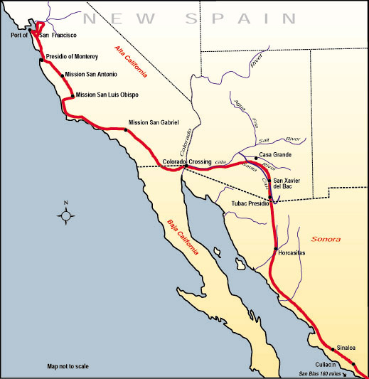
English: Map of the route, Juan Bautista de Anza travelled in 1775-76 from Mexico to todays San Francisco, where he founded the Presidio of San Francisco. Español: Mapa de la ruta que Juan Bautista de Anza recorrió en 1775-76 desde México hasta la actual San Francisco, donde fundó el Presidio de San Francisco. |
|||
| Source | http://www.nps.gov/juba | |||
| Author | ||||
| Permission (Reusing this file) |
|
File history
Click on a date/time to view the file as it appeared at that time.
| Date/Time | Thumbnail | Dimensions | User | Comment | |
|---|---|---|---|---|---|
| current | 20:53, 10 July 2006 | | 519 × 533 (67 KB) | wikimediacommons>H-stt | {{Information |Description= Map of the route, Juan Bautista de Anza travelled in 1775-76 from Baja California to todays San Francisco, where he founded the Presidio of San Francisco |Source= http://www.nps.gov/juba |Date= |Author= |Permission= {{PD-USGov |
File usage
The following page uses this file: