File:Longueuil Quebec location diagram.PNG
Jump to navigation
Jump to search
No higher resolution available.
Longueuil_Quebec_location_diagram.PNG (325 × 315 pixels, file size: 46 KB, MIME type: image/png)
Summary
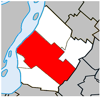
| Description |
English: Location of Longueuil, Quebec (boroughs outlined) within the Urban Agglomeration of Longueuil. |
| Date | |
| Source | Own work |
| Author | Gordalmighty |
Licensing
| I, the copyright holder of this work, release this work into the public domain. This applies worldwide. In some countries this may not be legally possible; if so: I grant anyone the right to use this work for any purpose, without any conditions, unless such conditions are required by law. |
File history
Click on a date/time to view the file as it appeared at that time.
| Date/Time | Thumbnail | Dimensions | User | Comment | |
|---|---|---|---|---|---|
| current | 04:51, 30 May 2009 | | 325 × 315 (46 KB) | wikimediacommons>MTLskyline | fix borders |
File usage
The following page uses this file: