File:Madeira topographic map-fr.svg
Jump to navigation
Jump to search

Size of this PNG preview of this SVG file: 690 × 599 pixels. Other resolutions: 276 × 240 pixels | 553 × 480 pixels | 884 × 768 pixels | 1,179 × 1,024 pixels | 2,358 × 2,048 pixels | 1,194 × 1,037 pixels.
Original file (SVG file, nominally 1,194 × 1,037 pixels, file size: 2.18 MB)
| Description |
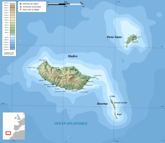
Français : Carte topographique en français de Madère Deutsch: Topographische Karte zum Madeira, in Französische English: Topographic and administrative map in French of Madeira Español: Mapa topográfico y administrativo en francès de Madeira Italiano: Carta topografica e amministrativa de Madera 日本語: フランス語で表示したマデイラ諸島の地形·行政地図 Português: Carta topográfica e da administração do Região Autónoma da Madeira em francês |
||
| Date | |||
| Source |
English: Own work ;
Français : Création personnelle ;
|
||
| Author | Bourrichon - fr:Bourrichon | ||
| Permission (Reusing this file) |
I, the copyright holder of this work, hereby publish it under the following licenses:
This file is licensed under the Creative Commons Attribution-Share Alike 3.0 Unported, 2.5 Generic, 2.0 Generic and 1.0 Generic license.
You may select the license of your choice. |
||
| Other versions |
File:Madeira topographic map-gl.svg File:Madeira topographic map-lt.svg File:Madeira topographic map-mk.svg |

| This SVG file contains embedded text that can be translated into your language, using any capable SVG editor, text editor or the SVG Translate tool. For more information see: About translating SVG files. |
File history
Click on a date/time to view the file as it appeared at that time.
| Date/Time | Thumbnail | Dimensions | User | Comment | |
|---|---|---|---|---|---|
| current | 18:55, 5 November 2011 | | 1,194 × 1,037 (2.18 MB) | wikimediacommons>Bourrichon | recorrect scale |
File usage
The following page uses this file: