File:Map Crusader states 1135-en.svg
Jump to navigation
Jump to search

Size of this PNG preview of this SVG file: 435 × 599 pixels. Other resolutions: 174 × 240 pixels | 348 × 480 pixels | 558 × 768 pixels | 744 × 1,024 pixels | 1,487 × 2,048 pixels | 955 × 1,315 pixels.
Original file (SVG file, nominally 955 × 1,315 pixels, file size: 418 KB)
Summary
| Description |
[]
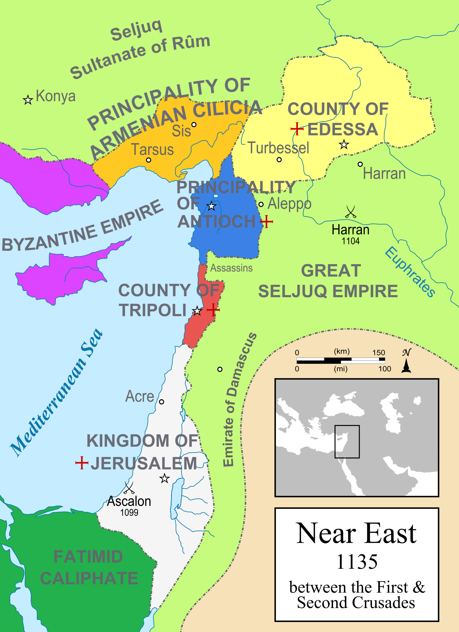
Čeština: Politická mapa Blízkého východu v roce 1135. Deutsch: Die Levante, 1135, zwischen den Ersten und Zweiten Kreuzzügen. Kreuzzugsstaaten sind mit einem roten Kreuz gekennzeichnet Eesti: Lähis-Ida (1135) Español: Oriente Próximo en 1135, entre la primera y segunda cruzadas. Esperanto: Politika mapo de Levantenio dum 1135, inter la krucmilitaroj unuaj kaj duaj. Français : Carte politique du Proche-Orient en 1135, entre la Première et la Seconde Croisades. les États latins d'Orient sont marqués d'une croix rouge. Galego: Mapa dos estados cruzados en Próximo Oriente polo 1135. Italiano: Carta politica del Vicino Oriente nel 1135. Magyar: A Közel-Kelet térképe 1135-ben. Polski: Mapa polityczna Bliskiego Wschodu w roku 1135, w okresie II krucjaty. Ελληνικά: Πολιτικός χάρτης της Μέσης Ανατολής το 1135, ανάμεσα στην πρώτη και τη δεύτερη Σταυροφορία Македонски: Политичка карта на Блискиот Исток во 1135 г. Крстоносните држави се означени со црвени крстови. Русский: Карта Ближнего Востока в 1135 г. Српски / srpski: Politička karta Bliskog Istoka 1135. godine, između Prvog i Drugog krstaškog pohoda. Krstaške države su označene crvenim krstom. ქართული: ახლო აღმოსავლეთი 1135 წელს ไทย: แผนที่ตะวันออกกลาง (คศ. 1135) ระหว่างครูเสดครั้งที่ 1 และครั่งที่ 2 中文: 一副关于1135年近东地区局势的地图,标注红色十字的为十字军国家 العربية : الدويلات الصليبية والدول الإسلامية المجاورة لها في الفترة بين الحملتين الصليبيتين الأولى والثانية. فارسی : نسخه فارسی No description.
|
||||||||||||||
| Source | Own work | ||||||||||||||
| Author | MapMaster | ||||||||||||||
| Other versions |
[]
See also |
||||||||||||||
| SVG development | |||||||||||||||


-ka.png)


References
- Bjorklund, Oddvar; Holmboe, Haakon; Rohr, Anders (1970) Historical Atlas of the World, Barnes & Noble, NY, SBN: 389-00253-4.
- Asia Minor and the Crusader states, c. 1140 from Findlay, Alexander G. (1849) Classical Atlas of Ancient Geography.
- Map of the Crusader states from Muir's Historical Atlas (1911)
Licensing
I, the copyright holder of this work, hereby publish it under the following license:

|
Permission is granted to copy, distribute and/or modify this document under the terms of the GNU Free Documentation License, Version 1.2 or any later version published by the Free Software Foundation; with no Invariant Sections, no Front-Cover Texts, and no Back-Cover Texts. A copy of the license is included in the section entitled GNU Free Documentation License. |
| This file is licensed under the Creative Commons Attribution-Share Alike 3.0 Unported license. | ||
| ||
| This licensing tag was added to this file as part of the GFDL licensing update. |
derivative works
Derivative works of this file:
- Map Crusader states 1135-ar.png
- Map Crusader states 1135-es.svg
- Map Crusader states 1135-zh.svg
- Map Crusader states 1135-es2.svg
File history
Click on a date/time to view the file as it appeared at that time.
| Date/Time | Thumbnail | Dimensions | User | Comment | |
|---|---|---|---|---|---|
| current | 21:01, 19 March 2015 | | 955 × 1,315 (418 KB) | wikimediacommons>Denniss | Reverted to version as of 09:13, 25 July 2012 |