File:Map of Lebanon.png
Jump to navigation
Jump to search
Map_of_Lebanon.png (325 × 349 pixels, file size: 10 KB, MIME type: image/png)
Map of Lebanon from de wiki[dead link]/CIA World Factbook. Attribution note: this image's update on 2010-09-23 was originally done by Shimgray at English Wikipedia.
This image is in the public domain because it contains materials that originally came from the United States Central Intelligence Agency's World Factbook.
|
 |
File history
Click on a date/time to view the file as it appeared at that time.
| Date/Time | Thumbnail | Dimensions | User | Comment | |
|---|---|---|---|---|---|
| current | 01:24, 2 July 2012 | 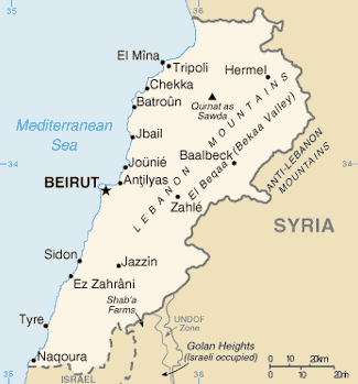 | 325 × 349 (10 KB) | wikimediacommons>Ras67 | cropped |
File usage
The following page uses this file: