File:Map of Sunda and Sahul.png
Jump to navigation
Jump to search

Size of this preview: 661 × 599 pixels. Other resolutions: 265 × 240 pixels | 530 × 480 pixels | 847 × 768 pixels | 1,111 × 1,007 pixels.
Original file (1,111 × 1,007 pixels, file size: 208 KB, MIME type: image/png)

|
File:Map of Sunda and Sahul.svg is a vector version of this file. It should be used in place of this PNG file when not inferior.
File:Map of Sunda and Sahul.png → File:Map of Sunda and Sahul.svg
For more information, see Help:SVG. |
 |
| Description |
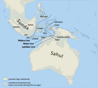
Deutsch: Karte von Sunda und Sahul sowie der Wallace-Linie, der Lydekker-Linie und der Weber-Linie.
Français : Carte de Sunda, de Sahul et de la ligne Wallace, de la ligne Lydekker et de la ligne Weber
Español: Mapa de Sunda y Sahul con la línea de Wallace, la línea de Lydekker y la línea de Weber.
|
| Date | |
| Source | Self made, using this map for the background |
| Author | Maximilian Dörrbecker (Chumwa) |
| Permission (Reusing this file) |
I, the copyright holder of this work, hereby publish it under the following license: This file is licensed under the Creative Commons Attribution-Share Alike 3.0 Unported license.
Sie dürfen das Bild zu den folgenden Bedingungen nutzen:
|
| Other versions |
|


File history
Click on a date/time to view the file as it appeared at that time.
| Date/Time | Thumbnail | Dimensions | User | Comment | |
|---|---|---|---|---|---|
| current | 08:07, 5 March 2017 | | 1,111 × 1,007 (208 KB) | wikimediacommons>Chumwa | corr |
File usage
The following page uses this file: