File:Mount Garibaldi topographic map-en.svg
Jump to navigation
Jump to search

Size of this PNG preview of this SVG file: 434 × 599 pixels. Other resolutions: 174 × 240 pixels | 348 × 480 pixels | 557 × 768 pixels | 742 × 1,024 pixels | 1,484 × 2,048 pixels | 906 × 1,250 pixels.
Original file (SVG file, nominally 906 × 1,250 pixels, file size: 318 KB)
Summary
| Description |
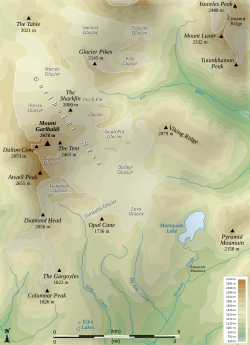
English: Topographic map of the Mount Garibaldi, a Canadian volcano.
Español: Mapa topográfica del Monte Garibaldi, un volcán canadiense.
Français : Carte topographique du Mont Garibaldi, un volcan Canadien. |
||
| Date | |||
| Source |
Own work, from :
|
||
| Author | Sémhur | ||
| Other versions |
File:Mount Garibaldi ASTER 2010-09-03.jpg : approximativement la même emprise ; File:Mount Garibaldi topographic map-fr.svg french version. | ||
| Attribution (required by the license) | © Sémhur / Wikimedia Commons / | ||
| SVG |
|
||
| Graphic Lab |
| Object location | | View this and other nearby images on: OpenStreetMap |
|---|
Licensing
I, the copyright holder of this work, hereby publish it under the following licenses:
Copyleft: This work of art is free; you can redistribute it and/or modify it according to terms of the Free Art License. You will find a specimen of this license on the Copyleft Attitude site as well as on other sites.
|
This file is licensed under the Creative Commons Attribution-Share Alike 4.0 International, 3.0 Unported, 2.5 Generic, 2.0 Generic and 1.0 Generic license.
- You are free:
- to share – to copy, distribute and transmit the work
- to remix – to adapt the work
- Under the following conditions:
- attribution – You must give appropriate credit, provide a link to the license, and indicate if changes were made. You may do so in any reasonable manner, but not in any way that suggests the licensor endorses you or your use.
- share alike – If you remix, transform, or build upon the material, you must distribute your contributions under the same or compatible license as the original.
You may select the license of your choice.
File history
Click on a date/time to view the file as it appeared at that time.
| Date/Time | Thumbnail | Dimensions | User | Comment | |
|---|---|---|---|---|---|
| current | 16:04, 25 May 2008 | | 906 × 1,250 (318 KB) | wikimediacommons>Sémhur | Corrected altitude of Dalton Cone and Atwell Peak. |
File usage
The following page uses this file: