File:My-map.png

From Vero - Wikipedia
Jump to navigation Jump to search

My-map.png (632 × 321 pixels, file size: 18 KB, MIME type: image/png)

This file is from Wikimedia Commons and may be used by other projects. The description on its file description page there is shown below.

Summary

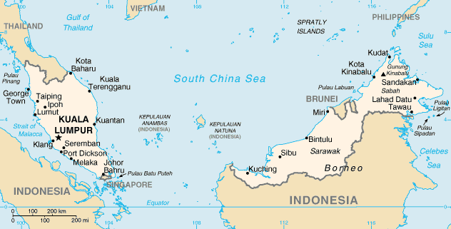
Map of Malaysia from the 2002 Factbook

Image extraction process This image has an extracted file: East Malaysia Map WorldFactBook.png.
lang=en

Licensing

Public domain
This image is in the public domain because it contains materials that originally came from the United States Central Intelligence Agency's World Factbook.

Bahasa Indonesia  čeština  Deutsch  eesti  English  español  Esperanto  français  galego  hrvatski  italiano  Nederlands  norsk nynorsk  polski  português  sicilianu  slovenščina  suomi  Türkçe  Zazaki  беларуская (тарашкевіца)  македонски  русский  српски / srpski  українська  ქართული  বাংলা  தமிழ்  മലയാളം  한국어  日本語  中文  中文(简体)  中文(繁體)  العربية  +/−

Captions

Add a one-line explanation of what this file represents

Items portrayed in this file

depicts

18,178 byte

321 pixel

632 pixel

image/png

265b175f9edca8b23e4116b7494c0eabb4b614d8

File history

Click on a date/time to view the file as it appeared at that time.

Date/TimeThumbnailDimensionsUserComment
current05:15, 28 November 2010Thumbnail for version as of 05:15, 28 November 2010632 × 321 (18 KB)wikimediacommons>Ras67cropped

The following 2 pages use this file: