File:Norge Fjorder1.png
Jump to navigation
Jump to search

Size of this preview: 354 × 600 pixels. Other resolutions: 141 × 240 pixels | 283 × 480 pixels | 993 × 1,683 pixels.
Original file (993 × 1,683 pixels, file size: 81 KB, MIME type: image/png)
| Description |
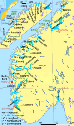
Deutsch: Bedeutende Fjorde und Seen Norwegens. Atypische Fjorde, die mehr von Inseln als von Festland umgeben sind, sind ohne farbliche Hervorhebung beschriftet. Anmerkung das Artikelsuffix "-en" am Namensende wurde in der Regel weggelassen. In manchen Namen kann dieses Suffix auch mitten im Namen erscheinen (Namsenfjord = Namsfjord, Saltenfjord = Saltfjord). Hier wurde die Version ohne dieses "-en" gewählt, die auch in den Cappellens®-Karten steht. Wo die Küstenlinie verschmiert aussieht, ist Schärenküste. English: Important fjords and lakes of Norway. Atypical fjords, rather surrounded by Islands than a bay, are texted whithout beeing marked with bricht colours. Remark: The suffix "-en", which is the Norwegian article, mostly has not been used in this map. In some names this "-en" can be placed or not be placed inside the name (Namsenfjord = Namsfjord, Saltenfjord = Saltfjord). In this map the version without inner "-en" has been choosen, as it is written in Cappellen's® maps. Where the graphic coastline appears blurred, there are skærs, in reality. |
| Date | |
| Source | Own work |
| Author | Ulamm 22:44, 16 December 2007 (UTC) |

|
This map has been made or improved in the German Kartenwerkstatt (Map Lab). You can propose maps to improve as well.
|
The map has been created with the Generic Mapping Tools: https://www.generic-mapping-tools.org/ using one or more of these public-domain datasets for the relief:
|

|
Permission is granted to copy, distribute and/or modify this document under the terms of the GNU Free Documentation License, Version 1.2 or any later version published by the Free Software Foundation; with no Invariant Sections, no Front-Cover Texts, and no Back-Cover Texts. A copy of the license is included in the section entitled GNU Free Documentation License. |
| This file is licensed under the Creative Commons Attribution-Share Alike 3.0 Unported license. | ||
| ||
| This licensing tag was added to this file as part of the GFDL licensing update. |
File history
Click on a date/time to view the file as it appeared at that time.
| Date/Time | Thumbnail | Dimensions | User | Comment | |
|---|---|---|---|---|---|
| current | 01:59, 2 March 2015 | | 993 × 1,683 (81 KB) | wikimediacommons>Ulamm | once more |
File usage
The following page uses this file: