File:Northumberland and County Durham location map.svg
Jump to navigation
Jump to search

Size of this PNG preview of this SVG file: 494 × 600 pixels. Other resolutions: 198 × 240 pixels | 395 × 480 pixels | 633 × 768 pixels | 843 × 1,024 pixels | 1,687 × 2,048 pixels | 1,108 × 1,345 pixels.
Original file (SVG file, nominally 1,108 × 1,345 pixels, file size: 315 KB)
Summary
| Description |
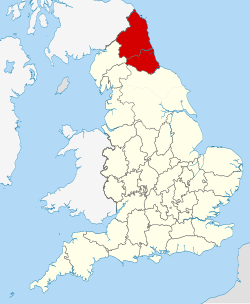
English: A map of Modern Northumbria, defined as "an area of north-eastern England comprising Northumberland, Durham, and Tyne and Wear"
[1] |
| Date | |
| Source |
This file was derived from: English ceremonial counties 2010.svg: |
| Author | User:Nilfanion |
Licensing
This file is licensed under the Creative Commons Attribution-Share Alike 4.0 International license.
- You are free:
- to share – to copy, distribute and transmit the work
- to remix – to adapt the work
- Under the following conditions:
- attribution – You must give appropriate credit, provide a link to the license, and indicate if changes were made. You may do so in any reasonable manner, but not in any way that suggests the licensor endorses you or your use.
- share alike – If you remix, transform, or build upon the material, you must distribute your contributions under the same or compatible license as the original.
File history
Click on a date/time to view the file as it appeared at that time.
| Date/Time | Thumbnail | Dimensions | User | Comment | |
|---|---|---|---|---|---|
| current | 02:30, 3 January 2019 | | 1,108 × 1,345 (315 KB) | wikimediacommons>NorthhymbraRice | Historic boundaries |
File usage
The following page uses this file: