File:Oranje1547.png
Oranje1547.png (167 × 216 pixels, file size: 61 KB, MIME type: image/png)
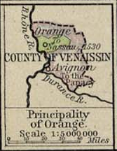
Dutch: Deze afbeelding is afkomstig uit de kaartencollectie van de University of Texas (http://www.lib.utexas.edu/maps/). Deze kaarten bevinden zich in het publiek domein (http://www.lib.utexas.edu/maps/faq.html#3.html). [1]
![[1]](https://nl.wikipedia.org/wiki/Afbeelding:Oranje1547.png)
English: This map is from the Perry-Castañeda Library Map Collection of the University of Texas. This particular map is from William Shephards Historical Atlas (1926 edition). It is therefore in public domain. See also (http://www.lib.utexas.edu/maps/faq.html#3.html)
|
This work is in the public domain in its country of origin and other countries and areas where the copyright term is the author's life plus 70 years or fewer. | |
| This file has been identified as being free of known restrictions under copyright law, including all related and neighboring rights. | |
File history
Click on a date/time to view the file as it appeared at that time.
| Date/Time | Thumbnail | Dimensions | User | Comment | |
|---|---|---|---|---|---|
| current | 21:57, 26 September 2007 | | 167 × 216 (61 KB) | wikimediacommons>Ale flashero | Oranje 1547.png Deze afbeelding is afkomstig uit de kaartencollectie van de University of Texas (http://www.lib.utexas.edu/maps/). Deze kaarten bevinden zich in het publiek domein (http://www.lib.utexas.edu/maps/faq.html#3.html). [http://nl.wikipedia.org/ |
File usage
The following 2 pages use this file: