File:Ordos Block.png
Jump to navigation
Jump to search

Size of this preview: 517 × 600 pixels. Other resolutions: 207 × 240 pixels | 414 × 480 pixels | 662 × 768 pixels | 883 × 1,024 pixels | 1,912 × 2,218 pixels.
Original file (1,912 × 2,218 pixels, file size: 4.63 MB, MIME type: image/png)
Summary
| Description |
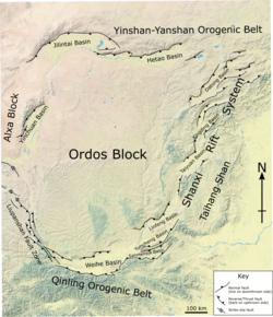
English: Map of the Ordos Block, showing the main structures that form its boundaries. The basemap is taken from a cropped version of File:China topography full res.jpg. The location and naming of basins and the faults are taken from Li et al. (2015) and Shi et al. (2019). |
| Date | |
| Source | Own work |
| Author | Mikenorton |
Licensing
I, the copyright holder of this work, hereby publish it under the following license:
This file is licensed under the Creative Commons Attribution-Share Alike 4.0 International license.
- You are free:
- to share – to copy, distribute and transmit the work
- to remix – to adapt the work
- Under the following conditions:
- attribution – You must give appropriate credit, provide a link to the license, and indicate if changes were made. You may do so in any reasonable manner, but not in any way that suggests the licensor endorses you or your use.
- share alike – If you remix, transform, or build upon the material, you must distribute your contributions under the same or compatible license as the original.
File history
Click on a date/time to view the file as it appeared at that time.
| Date/Time | Thumbnail | Dimensions | User | Comment | |
|---|---|---|---|---|---|
| current | 21:29, 20 December 2021 | | 1,912 × 2,218 (4.63 MB) | wikimediacommons>Mikenorton | Added label for Sanmenxia Basin |
File usage
The following page uses this file: