File:Pearl map lrg.gif
Jump to navigation
Jump to search
No higher resolution available.
Pearl_map_lrg.gif (600 × 540 pixels, file size: 18 KB, MIME type: image/gif)
Summary
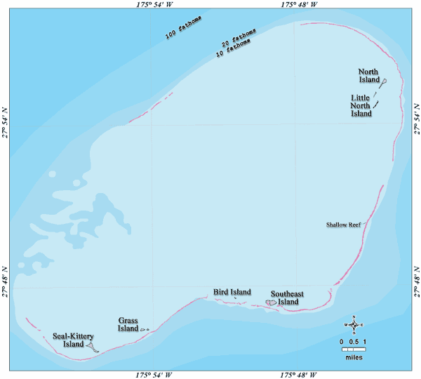
| Description |
Deutsch: Bathymetrische Karte des Pearl-und-Hermes-Atolls, Nordwestliche Hawaii-Inseln
English: Bathymetric map of Pearl and Hermes Atoll, Northwestern Hawaiian Islands |
| Date | not specified |
| Source | http://www.papahanaumokuakea.gov/imagery/graphicsmaps.html |
| Author | Christine Taylor, NOAA's National Marine Sanctuary Program |
| Permission (Reusing this file) |
credit to NOAA is preferred |
Licensing
This image is in the public domain because it contains materials that originally came from the U.S. National Oceanic and Atmospheric Administration, taken or made as part of an employee's official duties.
|
Original upload log
Original Uploader was Ratzer (talk) at 5 July 2006.
15:35, 5 July 2006 Ratzer (Talk | contribs) (http://hawaiireef.noaa.gov/imagery/graphicmaps.html archive copy at the Wayback Machine)
File history
Click on a date/time to view the file as it appeared at that time.
| Date/Time | Thumbnail | Dimensions | User | Comment | |
|---|---|---|---|---|---|
| current | 11:30, 21 February 2007 | | 600 × 540 (18 KB) | wikimediacommons>Telim tor | == Information == {{Information |Description=en: Bathymetric map of Pearl and Hermes Atoll, Northwestern Hawaiian Islands de: Bathymetrische Karte des Pearl und Hermes-Atolls, Nordwestliche Hawaiische Inseln |Source=http://www.hawaiireef.noaa.gov/imagery |
File usage
The following page uses this file: