File:Polish language in 1910.png
Jump to navigation
Jump to search
No higher resolution available.
Polish_language_in_1910.png (378 × 386 pixels, file size: 89 KB, MIME type: image/png)
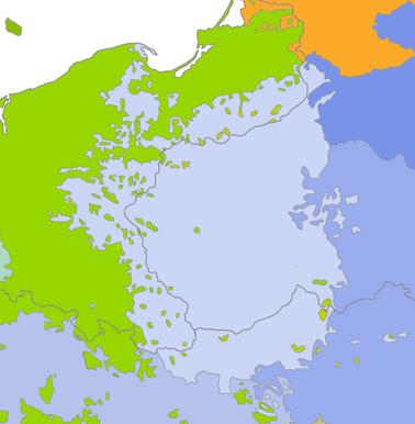
Legend
NOTE: The colored sections of the map indicate the area in which a certain language had a majority (i.e 51% or more) of speakers. They do not represent an area in which that particular language was spoken exclusively. This is especially true in the border regions.
German dialects.(Germanic, West)
Danish dialects. (Germanic, North)
Polish dialects.(Slavic, West)
Czech/Slovak dialects.(Slavic, West)
Belarusian dialects. (Slavic, East)
Ukrainian dialects. (Slavic, East)
Sorbian dialects. (Slavic, West)
Lithuanian dialects. (Baltic)
Summary
| Description |
English: A map of the linguistic situation in Central Europe around the year 1910. Based on a map by Dr. V. Schmidt and Dr. J. Metelka. |
| Date | |
| Source | Own work |
| Author | HP1740-B |
| Permission (Reusing this file) |
HP1740-B (talk) 17:08, 28 April 2009 (UTC) |
HP1740-B (talk) 17:08, 28 April 2009 (UTC)
Licensing
| I, the copyright holder of this work, release this work into the public domain. This applies worldwide. In some countries this may not be legally possible; if so: I grant anyone the right to use this work for any purpose, without any conditions, unless such conditions are required by law. |
File history
Click on a date/time to view the file as it appeared at that time.
| Date/Time | Thumbnail | Dimensions | User | Comment | |
|---|---|---|---|---|---|
| current | 17:08, 28 April 2009 | | 378 × 386 (89 KB) | wikimediacommons>HP1740-B~commonswiki | {{Information |Description={{en|1=A map of the linguistic situation in Central Europe around the year 1910. Based on a map by Dr. V. Schmidt and Dr. J. Metelka.}} |Source=Own work by uploader |Author=HP1740-B |Date=28-4-09 |Permission=~~ |
File usage
The following page uses this file: