File:Proposed Map of C and O Canal.jpg
Jump to navigation
Jump to search
Original file (4,074 × 2,322 pixels, file size: 5.91 MB, MIME type: image/jpeg)
Summary
| Description |
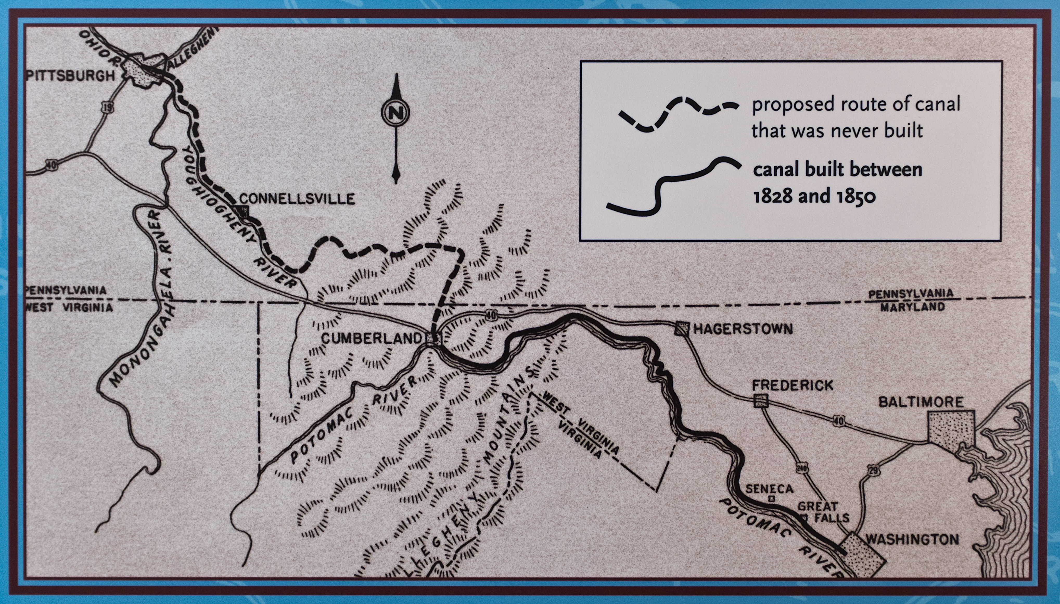
English: Proposed Map of Chesapeake and Ohio Canal, including portions never built. The line follows Wills Creek north from Cumberland to Hyndman PA, continues north up Little Wills Creek north and west. It crosses the Eastern Divide, follows Buffalo Creek (just south of Berlin PA) to Garret PA on the Casselman River. It then follows the Casselman river to the Youghiogheny River at Confluence, PA, then to Connellsville PA. |
|||
| Source |
United States Dept. of Interior. National Park Service information sign in Great Falls Tavern, Great Falls, MD, on the Chesapeake and Ohio Canal. It is one of several which are part of the historical exhibit of the Canal.
|
|||
| Author | United States Dept. of Interior, National Park Service |

Licensing
This work is in the public domain in the United States because it is a work prepared by an officer or employee of the United States Federal Government as part of that person’s official duties under the terms of Title 17, Chapter 1, Section 105 of the US Code.
Note: This only applies to original works of the Federal Government and not to the work of any individual U.S. state, territory, commonwealth, county, municipality, or any other subdivision. This template also does not apply to postage stamp designs published by the United States Postal Service since 1978. (See § 313.6(C)(1) of Compendium of U.S. Copyright Office Practices). It also does not apply to certain US coins; see The US Mint Terms of Use.
|
 | |
| This file has been identified as being free of known restrictions under copyright law, including all related and neighboring rights. | ||
File history
Click on a date/time to view the file as it appeared at that time.
| Date/Time | Thumbnail | Dimensions | User | Comment | |
|---|---|---|---|---|---|
| current | 23:21, 6 May 2013 | No thumbnail | 4,074 × 2,322 (5.91 MB) | wikimediacommons>Bonnachoven | Close up and crop of the proposed map. |
File usage
The following 2 pages use this file: