File:Pula Aerial View.jpg
Jump to navigation
Jump to search
Size of this preview: 800 × 488 pixels. Other resolutions: 320 × 195 pixels | 640 × 390 pixels | 1,024 × 625 pixels | 1,495 × 912 pixels.
Original file (1,495 × 912 pixels, file size: 1.01 MB, MIME type: image/jpeg)

|
This image has been assessed under the valued image criteria and is considered the most valued image on Commons within the scope: Pula, Croatia. You can see its nomination here. |
| Description |
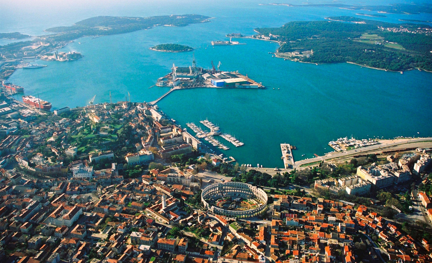
English: Aerial view of Pula, Croatia. The most notable object, on the bottom of the photo, is the Arena Amphiteathre. Left of it is the hill around which lies the Old Town. The wedge-shaped island in the middle of the bay is Uljanik, part of the shipyard. On the far top right the Brijuni islands (a National Park) can be seen.
Русский: Вид с высоты птичьего полета на Пулу (Хорватия). Самый примечательный объект, расположенный в нижней части фотографии, это амфитеатр Пулы. Слева от него находится холм, вокруг которого раскинулся Старый город. Клиновидный остров посреди бухты - это Uljanik, часть верфи. В дальнем правом верхнем углу видны острова Бриони (национальный парк). |
||||||||
| Date | 02:57, 19 ago 2007 (dati Exif) | ||||||||
| Source |
self-made, better version than |
||||||||
| Author | Orlovic | ||||||||
| Permission (Reusing this file) |
|
| Camera location | | View this and other nearby images on: OpenStreetMap |
|---|
Notes
- I uploaded it also on Panoramio, but only after doing it on commons --Orlovic 21:40, 5 February 2007 (UTC)

|
Permission is granted to copy, distribute and/or modify this document under the terms of the GNU Free Documentation License, Version 1.2 or any later version published by the Free Software Foundation; with no Invariant Sections, no Front-Cover Texts, and no Back-Cover Texts. A copy of the license is included in the section entitled GNU Free Documentation License. |
| This file is licensed under the Creative Commons Attribution-Share Alike 3.0 Unported license. | ||
| ||
| This licensing tag was added to this file as part of the GFDL licensing update. |
| Annotations | This image is annotated: View the annotations at Commons |
File history
Click on a date/time to view the file as it appeared at that time.
| Date/Time | Thumbnail | Dimensions | User | Comment | |
|---|---|---|---|---|---|
| current | 01:06, 19 August 2007 | | 1,495 × 912 (1.01 MB) | wikimediacommons>OffTopic11 | {{Information |Description=Aerial view of Pula, Croatia |Source= My friend gave me the photo to publish under GFDL, better version than 50px |Date= |Author= Darko D. |permission={{GFDL}} }} == Notes == *I uploaded it also on [htt |
File usage
The following 2 pages use this file: