File:RUS-2016-Aerial-SPB-Peter and Paul Fortress 02.jpg
Jump to navigation
Jump to search

Size of this preview: 800 × 458 pixels. Other resolutions: 320 × 183 pixels | 640 × 366 pixels | 1,024 × 586 pixels | 1,280 × 732 pixels | 2,560 × 1,465 pixels | 6,723 × 3,847 pixels.
Original file (6,723 × 3,847 pixels, file size: 17.54 MB, MIME type: image/jpeg)
Summary
| Description |
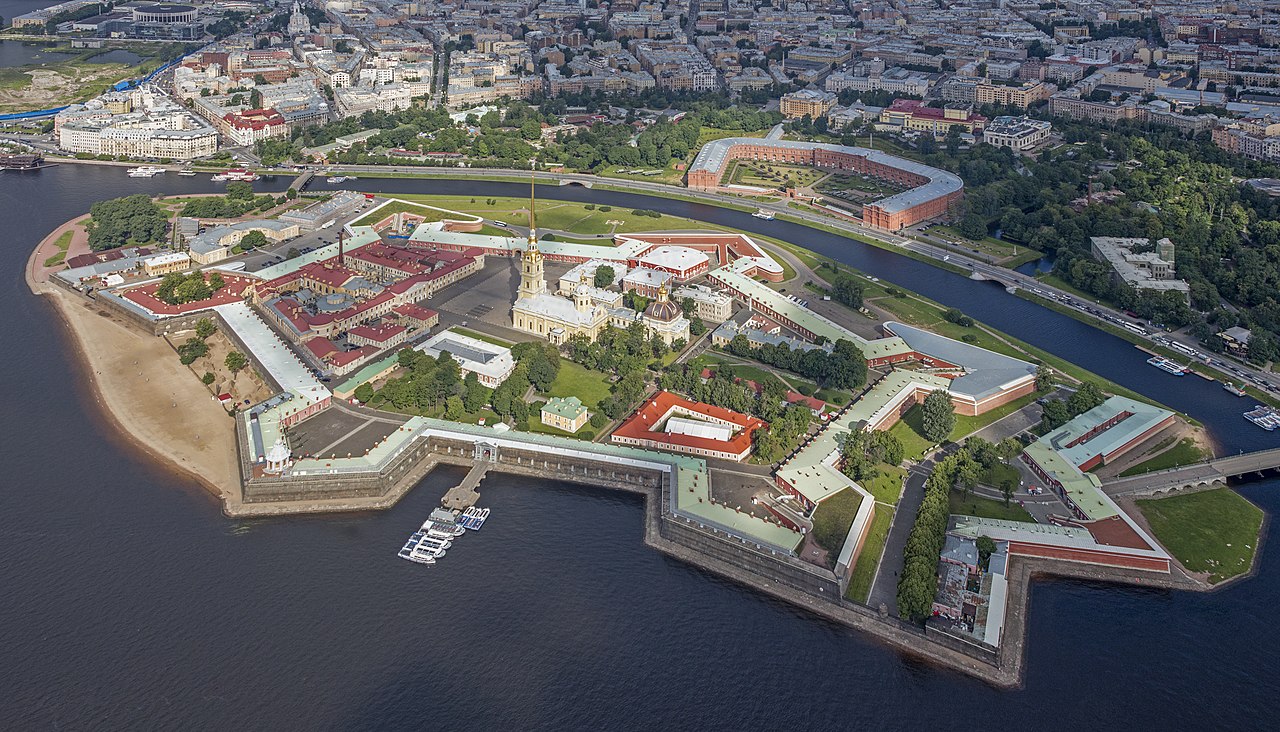
English: Aerial view of Peter and Paul Fortress on Zayachy Island, Saint Petersburg, Russia. To the north, across the Kronverksky Strait is the Kronverk, including the Artillery Museum.
Polski: Widok z lotu ptaka na Twierdzę Pietropawłowską położoną na Wyspie Zajęczej w Petersburgu, w Rosji.
Deutsch: Luftbild der Peter und Paul Festung auf der Zayachy Insel, Sankt Petersburg. Nördlich, über den Kronwerk-Kanal ist das Kronwerk auf der Petrograder Insel, inklusive des Militärgeschichtlichen Museums. |
||||
| Date | |||||
| Source | Own work | ||||
| Author | Godot13 | ||||
| Attribution (required by the license) | Andrew Shiva / Wikipedia / | ||||
| Camera location | | View this and other nearby images on: OpenStreetMap |
|---|

|
This image was uploaded as part of Wiki Loves Monuments 2016.
|
Assessment
|
This image was selected as picture of the day on Wikimedia Commons for 27 May 2018. It was captioned as follows: Other languages:
Polski: Widok z lotu ptaka na Twierdzę Pietropawłowską położoną na Wyspie Zajęczej w Petersburgu, w Rosji. |

|
This image was awarded an finalist in the national contest of Russia in Wiki Loves Monuments 2016 Other languages:
|
This image was selected as picture of the day on Bengali Wikipedia.
|

|
This image has been assessed under the valued image criteria and is considered the most valued image on Commons within the scope: Peter & Paul Fortress aerial views. You can see its nomination here. |
Licensing
I, the copyright holder of this work, hereby publish it under the following license:
This file is licensed under the Creative Commons Attribution-Share Alike 4.0 International license.
- You are free:
- to share – to copy, distribute and transmit the work
- to remix – to adapt the work
- Under the following conditions:
- attribution – You must give appropriate credit, provide a link to the license, and indicate if changes were made. You may do so in any reasonable manner, but not in any way that suggests the licensor endorses you or your use.
- share alike – If you remix, transform, or build upon the material, you must distribute your contributions under the same or compatible license as the original.

|
The copyright holder of this file, Andrew Shiva, allows anyone to use it for any purpose, provided that the copyright holder is properly attributed. Redistribution, derivative work, commercial use, and all other use is permitted. |
Attribution:
Use or reproduction of this image outside of Wikipedia must give the original photographer (Andrew Shiva) credit. Although not required, it would be appreciated if a message was left here indicating where this image was being used.
|
| Annotations | This image is annotated: View the annotations at Commons |
File history
Click on a date/time to view the file as it appeared at that time.
| Date/Time | Thumbnail | Dimensions | User | Comment | |
|---|---|---|---|---|---|
| current | 20:34, 30 September 2016 | | 6,723 × 3,847 (17.54 MB) | wikimediacommons>Godot13 | highlights/shadows |
File usage
The following page uses this file: