File:Radarsurvey.jpg
Jump to navigation
Jump to search

Size of this preview: 450 × 600 pixels. Other resolutions: 180 × 240 pixels | 480 × 640 pixels.
Original file (480 × 640 pixels, file size: 137 KB, MIME type: image/jpeg)
Summary
| Description |
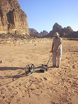
English: Ground penetrating radar (GPR) survey at the Nabataeo-Roman site of Wadi Ramm, Jordan. The wheel trailing behind the transmitter/receiver antennas is an odometer that controls data collection. |
| Date |
2 January 2005 (according to Exif data) |
| Source | http://www.archaeophysics.com |
| Author | Archaeo-Physics LLC |
| Permission (Reusing this file) |
|
Licensing
| This work has been released into the public domain by its author, Archaeo-Physics LLC. This applies worldwide. In some countries this may not be legally possible; if so: Archaeo-Physics LLC grants anyone the right to use this work for any purpose, without any conditions, unless such conditions are required by law.
|
Original upload log
Transferred from en.wikipedia to Commons using For the Common Good.
The original description page was here. All following user names refer to en.wikipedia.
| Date/Time | Dimensions | User | Comment |
|---|---|---|---|
| 21:10, 9 February 2006 | 480 × 640 (140,526 bytes) | w:en:Tapatio (talk | contribs) | Ground penetrating radar survey. The wheel trailing behind the transmitter/receiver antennas is an odometer that contrls data collection. |
File history
Click on a date/time to view the file as it appeared at that time.
| Date/Time | Thumbnail | Dimensions | User | Comment | |
|---|---|---|---|---|---|
| current | 12:45, 26 October 2014 | | 480 × 640 (137 KB) | wikimediacommons>Kelly | Transferred from en.wikipedia: see original upload log above |
File usage
The following page uses this file: