File:Rhein-Karte.png
Jump to navigation
Jump to search

Size of this preview: 427 × 599 pixels. Other resolutions: 171 × 240 pixels | 342 × 480 pixels | 794 × 1,114 pixels.
Original file (794 × 1,114 pixels, file size: 73 KB, MIME type: image/png)
| Description |
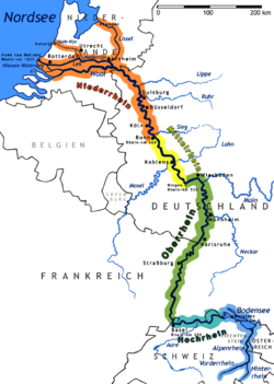
Deutsch: Die Karte zeigt den Fluss Rhein English: The map shows the river Rhine |
| Date | |
| Source | Rhine river |
| Author | Alice F.A. Mutton Karl A. Sinnhuber (Enc. Britannica) |
| Permission (Reusing this file) |
Daniel Ullrich (Threedots) , |
| Other versions | corrected & improved: File:Rhein-Karte2.png |
Map of the Rhine
- The map of the river from source to mouth r Rhine
- "drawn" by myself, Daniel Ullrich (Threedots) with Adobe Photoshop 6.0 in January 2005
- If you ask for, I will give you the .psd- / .xfc-file or I'll correct it or create another language version
Karte des Rhein
- Die Karte zeigt den Fluss Rhein
- von mir selbst, Daniel Ullrich (Threedots) im Januar 2005 mit Adobe Photoshop 6.0 "gezeichnet"
- Auf Anfrage stelle ich gern die .psd- / .xfc-Datei bereit oder erstelle selbst korrigierte oder andersprachige Versionen
- other versions = File:Rhein-Karte2.png (Überarbeitung durch / relaunched by Ulamm 02:38, 13 May 2014 (UTC))

|
File:Karte des Rhein.svg is a vector version of this file. It should be used in place of this PNG file when not inferior.
File:Rhein-Karte.png → File:Karte des Rhein.svg
For more information, see Help:SVG. |
 |
I, the copyright holder of this work, hereby publish it under the following licenses:

|
Permission is granted to copy, distribute and/or modify this document under the terms of the GNU Free Documentation License, Version 1.2 or any later version published by the Free Software Foundation; with no Invariant Sections, no Front-Cover Texts, and no Back-Cover Texts. A copy of the license is included in the section entitled GNU Free Documentation License. |
| This file is licensed under the Creative Commons Attribution-Share Alike 3.0 Unported license. | ||
| ||
| This licensing tag was added to this file as part of the GFDL licensing update. |
This file is licensed under the Creative Commons Attribution-Share Alike 2.0 Germany license.
- You are free:
- to share – to copy, distribute and transmit the work
- to remix – to adapt the work
- Under the following conditions:
- attribution – You must give appropriate credit, provide a link to the license, and indicate if changes were made. You may do so in any reasonable manner, but not in any way that suggests the licensor endorses you or your use.
- share alike – If you remix, transform, or build upon the material, you must distribute your contributions under the same or compatible license as the original.

You may select the license of your choice.
File history
Click on a date/time to view the file as it appeared at that time.
| Date/Time | Thumbnail | Dimensions | User | Comment | |
|---|---|---|---|---|---|
| current | 09:29, 21 April 2011 | | 794 × 1,114 (73 KB) | wikimediacommons>Huntster | Re-upload in attempt to force cache update (not showing up in articles). |
File usage
The following page uses this file: