File:Ruhr area-map.png
Jump to navigation
Jump to search
Size of this preview: 800 × 474 pixels. Other resolutions: 320 × 190 pixels | 640 × 380 pixels | 1,000 × 593 pixels.
Original file (1,000 × 593 pixels, file size: 86 KB, MIME type: image/png)

|
This locator map image could be re-created using vector graphics as an SVG file. This has several advantages; see Commons:Media for cleanup for more information. If an SVG form of this image is available, please upload it and afterwards replace this template with
{{vector version available|new image name}}.It is recommended to name the SVG file “Ruhr area-map.svg”—then the template Vector version available (or Vva) does not need the new image name parameter. |
Summary
| Description |
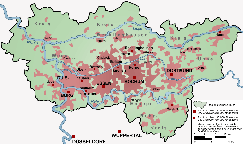
Deutsch: Karte des Ruhrgebiets, Deutschland – Die Karte zeigt das Ruhrgebiet (Regionalverband Ruhr) mit allen Städten über 50.000 Einwohnern.
English: Map of the Ruhr area, Germany – The map shows the Ruhr Area (Regionalverband Ruhr) with all cities with more than 50,000 inhabitants. |
| Date | |
| Source |
Own work Deutsch: von mir selbst, Threedots (Daniel Ullrich), mit Adobe Photoshop 6.0 „gezeichnet“; Datengrundlage: GeoDaten des Landesvermessungsamts NRW (damalige URL: www.ruhrgebiet.de/daten/geodatenserver.shtml) und verschiedene andere Karten
English: "drawn" by myself, Threedots (Daniel Ullrich), with Adobe Photoshop 6.0; used data set: official GeoData (former URL: www.ruhrgebiet.de/daten/geodatenserver.shtml) and several other maps |
| Author | Threedots (Daniel Ullrich) |
Licensing
Threedots (Daniel Ullrich), the copyright holder of this work, hereby publishes it under the following licenses:

|
Permission is granted to copy, distribute and/or modify this document under the terms of the GNU Free Documentation License, Version 1.2 or any later version published by the Free Software Foundation; with no Invariant Sections, no Front-Cover Texts, and no Back-Cover Texts. A copy of the license is included in the section entitled GNU Free Documentation License. |
| This file is licensed under the Creative Commons Attribution-Share Alike 3.0 Unported license. | ||
Attribution:
| ||
| ||
| This licensing tag was added to this file as part of the GFDL licensing update. |
This file is licensed under the Creative Commons Attribution-Share Alike 2.0 Germany license.
Attribution:
- You are free:
- to share – to copy, distribute and transmit the work
- to remix – to adapt the work
- Under the following conditions:
- attribution – You must give appropriate credit, provide a link to the license, and indicate if changes were made. You may do so in any reasonable manner, but not in any way that suggests the licensor endorses you or your use.
- share alike – If you remix, transform, or build upon the material, you must distribute your contributions under the same or compatible license as the original.

You may select the license of your choice.
File history
Click on a date/time to view the file as it appeared at that time.
| Date/Time | Thumbnail | Dimensions | User | Comment | |
|---|---|---|---|---|---|
| current | 15:07, 8 June 2010 | | 1,000 × 593 (86 KB) | wikimediacommons>NordNordWest | c |
File usage
The following 2 pages use this file: