File:SWE-Map NUTS1-NUTS2,2.svg
Jump to navigation
Jump to search

Size of this PNG preview of this SVG file: 263 × 599 pixels. Other resolutions: 105 × 240 pixels | 211 × 480 pixels | 337 × 768 pixels | 450 × 1,024 pixels | 900 × 2,048 pixels | 290 × 660 pixels.
Original file (SVG file, nominally 290 × 660 pixels, file size: 105 KB)
| Description |
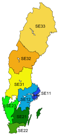
English: A map of the NUTS 1 (Lands) and NUTS 2 (National Areas) subdivisions of Sweden since 2008. The colour shows which Land a particular National Area belongs to.
Svenska: Sveriges Landsdelar (NUTS 1) och Riksområde (NUTS 2) sedan 2008. Färgerna anger vilken Landsdel ett riksområde tillhör. |
| Date | |
| Source |
Made by Lokal_Profil
|
| Author | Lokal_Profil |
| Permission (Reusing this file) |
This file is licensed under the Creative Commons Attribution-Share Alike 2.5 Generic license. Attribution:
|
File history
Click on a date/time to view the file as it appeared at that time.
| Date/Time | Thumbnail | Dimensions | User | Comment | |
|---|---|---|---|---|---|
| current | 23:00, 20 May 2010 | | 290 × 660 (105 KB) | wikimediacommons>Lokal Profil | {{Information |Description={{en|A map of the NUTS 1 (Lands) and NUTS 2 (National areas) subdivisions of Sweden since 2008. The colour shows which Land a particular National area belongs to.}} {{sv|Sveriges Landsdelar (NUTS 1) och Riksområde (NUTS 2) seda |
File usage
The following page uses this file: