File:St Moritz Muottas.jpg
Jump to navigation
Jump to search
Size of this preview: 800 × 533 pixels. Other resolutions: 320 × 213 pixels | 640 × 427 pixels | 1,024 × 683 pixels | 1,280 × 853 pixels | 1,920 × 1,280 pixels.
Original file (1,920 × 1,280 pixels, file size: 871 KB, MIME type: image/jpeg)
Summary
| Description |
Беларуская (тарашкевіца): Від на Сьв. Морыц і возера з Муотас да Шлярыгна, Грысонз. Швайцарыя.
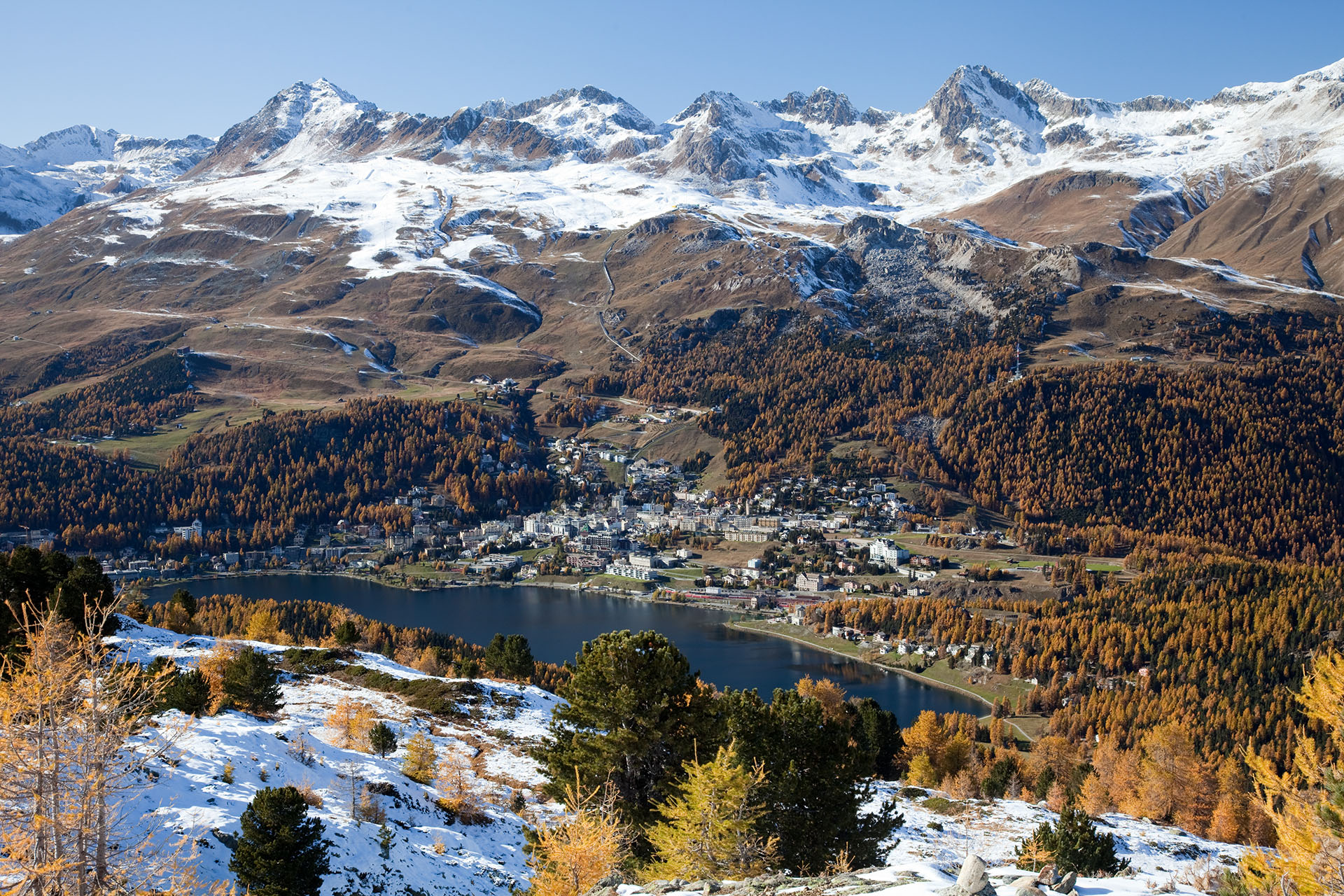
Deutsch: Blick auf St. Moritz, St. Moritzersee und Skigebiet Corviglia im Herbst von Muottas da Schlarigna – links Piz Nair (3056 m), Piz Grisch (3098 m) und Piz Corviglia (3060 m) in der Bildmitte, rechts der Piz Saluver (3159 m) und die Ausläufer des Piz Ot (3246 m) am Bildrand
English: View of St. Moritz and its lake, as seen from Muottas da Schlarigna, Grisons. Switzerland. On the left is Piz Nair (3056 m), to the right is Piz Saluver (3159 m)
Español: Vista de San Moritz y su lago. Tomado desde Muottas de Schlarigna, Grisones, Suiza.
Français : Vue sur Saint-Moritz et son lac, prise depuis Muottas da Schlarigna. Canton des Grisons (Suisse).
Rumantsch: Vista da Muottas da Schlarigna sin San Murezzan, il Lai da San Murezzan ed il territori da skis Corviglia. |
| Date | 21 October 2010 (according to Exif data) |
| Source | Own work |
| Author | Murdockcrc |
| Camera location | | View this and other nearby images on: OpenStreetMap |
|---|
|

This image was selected as picture of the day on Wikimedia Commons for 2 April 2011. It was captioned as follows: English: View of St. Moritz and the lake, as seen from Muottas da Schlarigna, Grisons. Switzerland. Other languages:
Deutsch: Aufnahme von St. Moritz mit St. Moritzersee, vom Muottas Muragl aus gesehen (Kanton Graubünden in der Schweiz) English: View of St. Moritz and the lake, as seen from Muottas da Schlarigna, Grisons. Switzerland. Español: Vista de Sankt Moritz y el lago desde Muottas da Schlarigna (Cantón de los Grisones, Suiza). Français : Saint-Moritz et son lac, vus de Muottas da Schlarigna, Grisons. Suisse. Nederlands: Panorama van St. Moritz en het Meer van Sankt Moritz, gezien vanaf Muottas da Schlarigna, Graubünden, Zwitserland. 中文: 瑞士圣莫里茨风景 |
This image has been assessed using the Quality image guidelines and is considered a Quality image.
|
Licensing
I, the copyright holder of this work, hereby publish it under the following licenses:

|
Permission is granted to copy, distribute and/or modify this document under the terms of the GNU Free Documentation License, Version 1.2 or any later version published by the Free Software Foundation; with no Invariant Sections, no Front-Cover Texts, and no Back-Cover Texts. A copy of the license is included in the section entitled GNU Free Documentation License. |
This file is licensed under the Creative Commons Attribution 3.0 Unported license.
- You are free:
- to share – to copy, distribute and transmit the work
- to remix – to adapt the work
- Under the following conditions:
- attribution – You must give appropriate credit, provide a link to the license, and indicate if changes were made. You may do so in any reasonable manner, but not in any way that suggests the licensor endorses you or your use.
You may select the license of your choice.
| Annotations | This image is annotated: View the annotations at Commons |
File history
Click on a date/time to view the file as it appeared at that time.
| Date/Time | Thumbnail | Dimensions | User | Comment | |
|---|---|---|---|---|---|
| current | 10:09, 29 November 2010 | | 1,920 × 1,280 (871 KB) | wikimediacommons>Murdockcrc | {{Information |Description={{en|1=View of St. Moritz and the lake, as seen from Muottas da Schlarigna, Grisons. Switzerland.}} {{es|1=Vista de San Moritz y su lago. Tomado desde Muottas de Schlarigna, Grisones, Suiza.}} |Source={{own}} |Author=[[User:Murd |
File usage
The following page uses this file: