File:Sunspot-bfly.gif

Original file (2,150 × 1,280 pixels, file size: 142 KB, MIME type: image/gif)
Summary
| Description |
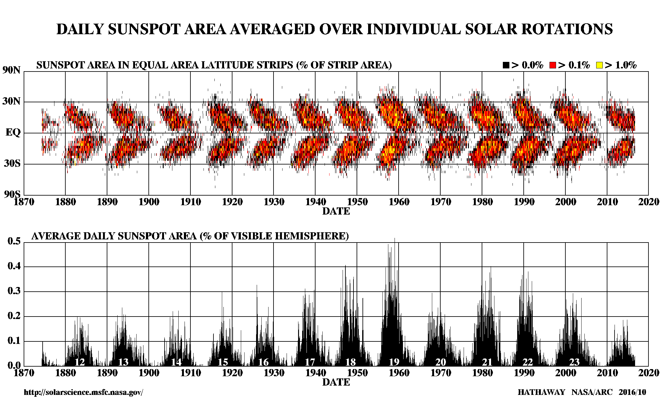
English: Daily sunspot area averaged over individual solar rotations. This is colloquially known as the "Butterfly Diagram".
Detailed observations of sunspots have been obtained by the Royal Greenwich Observatory since 1874. These observations include information on the sizes and positions of sunspots as well as their numbers. These data show that sunspots do not appear at random over the surface of the sun but are concentrated in two latitude bands on either side of the equator. A butterfly diagram (updated monthly) showing the positions of the spots for each rotation of the sun since May 1874 shows that these bands first form at mid-latitudes, widen, and then move toward the equator as each cycle progresses. — NASA, http://solarscience.msfc.nasa.gov/SunspotCycle.shtml |
|||||
| Date | 2013, NASA version 2013/11 shown here. | |||||
| Source | http://solarscience.msfc.nasa.gov/images/bfly.gif | |||||
| Author | David Hathaway, NASA, Marshall Space Flight Center | |||||
| Permission (Reusing this file) |
|

Original upload log
| Date/Time | Dimensions | User | Comment |
|---|---|---|---|
| 2013-11-07 19:24 | 1950×500× (88047 bytes) | Grolltech | updated to version 2013/11. |
| 2012-03-09 05:08 | 1950×500× (87477 bytes) | Speight | crop to match earlier versions |
| 2012-03-09 05:02 | 2048×1280× (137615 bytes) | Speight | updated version 2012-03 |
| 2011-04-22 04:16 | 1950×500× (90310 bytes) | 孟柏民 | another update |
| 2009-09-08 04:52 | 2048×506× (90295 bytes) | 孟柏民 | updated version |
| 2007-05-31 13:32 | 1872×500× (77217 bytes) | Paulchar | Author: David Hathaway, NASA Marshall Space Flight Center (http://solarscience.msfc.nasa.gov). Public-domain image. |
File history
Click on a date/time to view the file as it appeared at that time.
| Date/Time | Thumbnail | Dimensions | User | Comment | |
|---|---|---|---|---|---|
| current | 10:24, 20 December 2020 | | 2,150 × 1,280 (142 KB) | wikimediacommons>Q28 | update |
File usage
The following page uses this file: