File:Syria pop.jpg
Jump to navigation
Jump to search

Size of this preview: 408 × 599 pixels. Other resolutions: 163 × 240 pixels | 327 × 480 pixels | 682 × 1,002 pixels.
Original file (682 × 1,002 pixels, file size: 86 KB, MIME type: image/jpeg)
Summary
| Description |
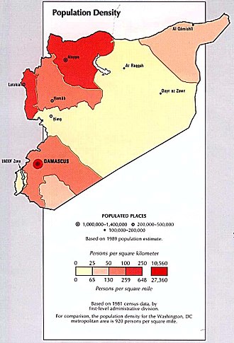
English: Syria - Population Density from the CIA Atlas of the Middle East 1993 (86K) |
| Source | Perry-Castañeda Library Map Collection at The University of Texas at Austin [1] |
| Author | |
| Permission (Reusing this file) |
Above a list of maps available for download, the web site has the text: The following maps were produced by the U.S. Central Intelligence Agency, unless otherwise indicated.. There is no indication that this map was not produced by the CIA. |
| Other versions |
 |

|
This map image could be re-created using vector graphics as an SVG file. This has several advantages; see Commons:Media for cleanup for more information. If an SVG form of this image is available, please upload it and afterwards replace this template with
{{vector version available|new image name}}.It is recommended to name the SVG file “Syria pop.svg”—then the template Vector version available (or Vva) does not need the new image name parameter. |


Licensing
| This image is a work of a Central Intelligence Agency employee, taken or made as part of that person's official duties. As a Work of the United States Government, this image or media is in the public domain in the United States.
|

|
File history
Click on a date/time to view the file as it appeared at that time.
| Date/Time | Thumbnail | Dimensions | User | Comment | |
|---|---|---|---|---|---|
| current | 09:10, 19 February 2007 | | 682 × 1,002 (86 KB) | wikimediacommons>Khoikhoi~commonswiki | ==Summary== '''Syria - Population Density from the CIA Atlas of the Middle East 1993 (86K)''' *Source: Perry-Castañeda Library Map Collection at The University of Texas at Austin [http://www.lib.utexas.edu/maps/middle_east.html] *License: Above a list o |
File usage
The following page uses this file: