File:Tribes in Ancient Thrace (English).png
Jump to navigation
Jump to search
Size of this preview: 600 × 600 pixels. Other resolutions: 240 × 240 pixels | 480 × 480 pixels | 768 × 768 pixels | 1,024 × 1,024 pixels | 2,048 × 2,048 pixels | 3,000 × 3,000 pixels.
Original file (3,000 × 3,000 pixels, file size: 7.85 MB, MIME type: image/png)
.png)

|
File:Tribes in Ancient Thrace (English).svg is a vector version of this file. It should be used in place of this PNG file when not inferior.
File:Tribes in Ancient Thrace (English).png → File:Tribes in Ancient Thrace (English).svg
For more information, see Help:SVG. |
.svg) |
Summary
| Description |
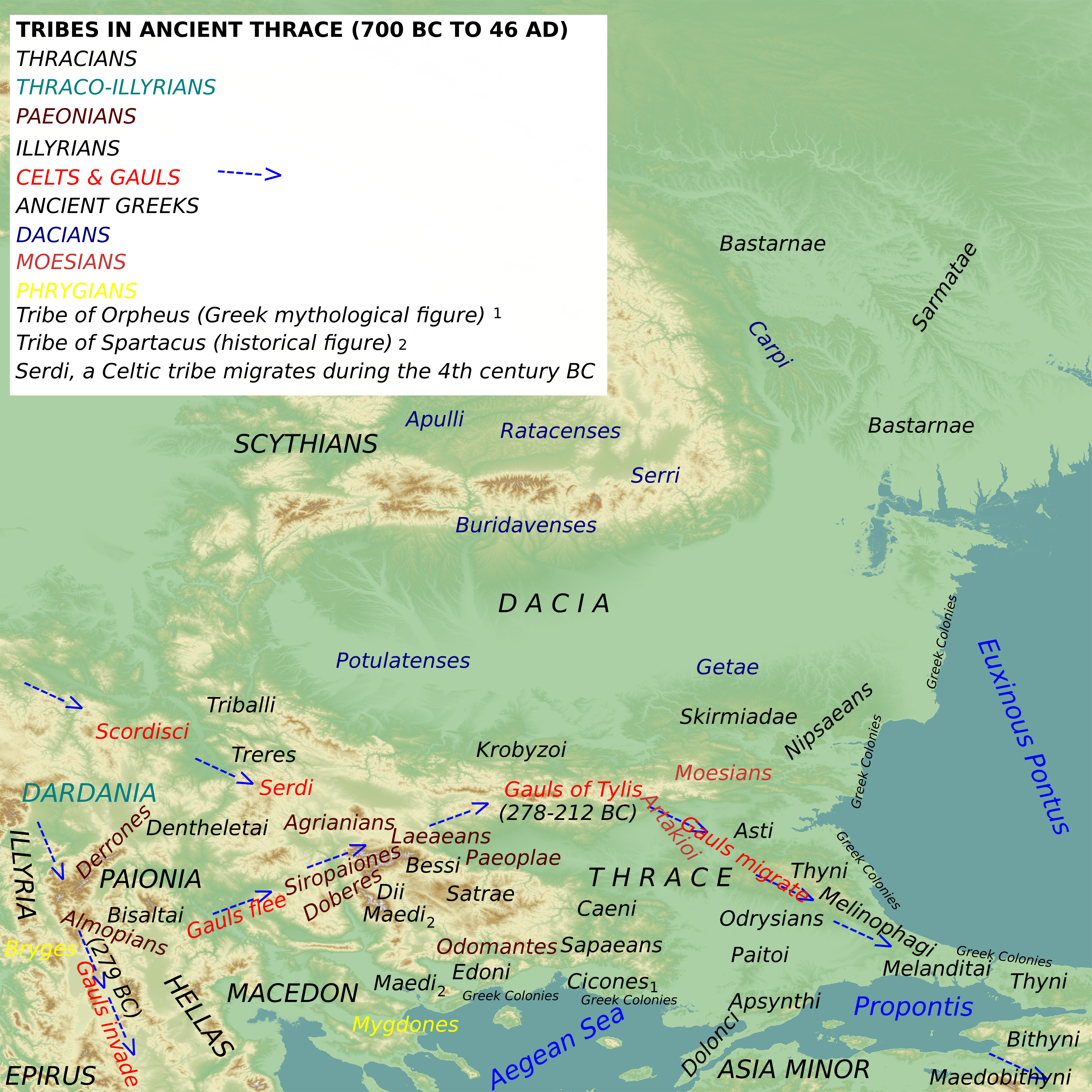
English: Map of Tribes inhabiting Thrace and Environs, Tribes in Thrace pre-Roman conquest. Includes migrations of Celts and Gauls. |
| Date | |
| Source | Own work |
| Author | MaryroseB54 |
- The Thracians 700 BC-AD 46 (Men-at-Arms) by Christopher Webber and Angus McBride,ISBN-10: 1841763292,2001
- The Odrysian Kingdom of Thrace: Orpheus Unmasked (Oxford Monographs on Classical Archaeology) by Z. H. Archibald,1998,ISBN-10-0198150474
- Dacia: Landscape, Colonization and Romanization by Ioana A Oltean, ISBN 0415412528, 2007
- Map 1: Thracian Tribal areas (from Fol, Thrace and the Thracians, p 133)
- The Thracians 700 BC–AD 46 (Men-at-Arms 360) by Christopher Webber
- After Hoddinot, Col & Cah
- Wilkes, J. J. The Illyrians, 1992,ISBN 0631198075
- The Cambridge Ancient History, Volume 3, Part 2: The Assyrian and Babylonian Empires and Other States of the Near East, from the Eighth to the Sixth Centuries BC by John Boardman, I. E. S. Edwards, E. Sollberger, and N. G. L. Hammond ,ISBN-10: 0521227178,1992
- Blank map is Basemap_for_Afil.png
Licensing
I, the copyright holder of this work, hereby publish it under the following license:
This file is licensed under the Creative Commons Attribution-Share Alike 4.0 International license.
- You are free:
- to share – to copy, distribute and transmit the work
- to remix – to adapt the work
- Under the following conditions:
- attribution – You must give appropriate credit, provide a link to the license, and indicate if changes were made. You may do so in any reasonable manner, but not in any way that suggests the licensor endorses you or your use.
- share alike – If you remix, transform, or build upon the material, you must distribute your contributions under the same or compatible license as the original.
File history
Click on a date/time to view the file as it appeared at that time.
| Date/Time | Thumbnail | Dimensions | User | Comment | |
|---|---|---|---|---|---|
| current | 10:10, 22 July 2016 | | 3,000 × 3,000 (7.85 MB) | wikimediacommons>MaryroseB54 | User created page with UploadWizard |
File usage
The following page uses this file:
.png)