Province of Verbano-Cusio-Ossola
Template:Short description Template:Use dmy dates Template:Main other{{#invoke:Infobox|infobox}}Template:Template other{{#invoke:Check for unknown parameters|check|unknown=Template:Main other|preview = Page using [[Template:Template:If empty]] with unknown parameter "_VALUE_"|ignoreblank=y|mapframe_args=y | alt | anthem | anthem_link | area_blank1_acre | area_blank1_dunam | area_blank1_ha | area_blank1_km2 | area_blank1_sq_mi | area_blank1_title | area_blank2_acre | area_blank2_dunam | area_blank2_ha | area_blank2_km2 | area_blank2_sq_mi | area_blank2_title | area_code | area_code_type | area_codes | area_footnotes | area_land_acre | area_land_dunam | area_land_ha | area_land_km2 | area_land_sq_mi | area_metro_acre | area_metro_dunam | area_metro_footnotes | area_metro_ha | area_metro_km2 | area_metro_sq_mi | area_note | area_rank | area_rural_acre | area_rural_dunam | area_rural_footnotes | area_rural_ha | area_rural_km2 | area_rural_sq_mi | area_total_acre | area_total_dunam | area_total_ha | area_total_km2 | area_total_sq_mi | area_urban_acre | area_urban_dunam | area_urban_footnotes | area_urban_ha | area_urban_km2 | area_urban_sq_mi | area_water_acre | area_water_dunam | area_water_ha | area_water_km2 | area_water_percent | area_water_sq_mi | blank_emblem_alt | blank_emblem_link | blank_emblem_size | blank_emblem_type | blank_emblem_sizedefault | blank_emblem_upright | blank_info | blank_info_sec1 | blank_info_sec2 | blank_name | blank_name_sec1 | blank_name_sec2 | blank1_info | blank1_info_sec1 | blank1_info_sec2 | blank1_name | blank1_name_sec1 | blank1_name_sec2 | blank2_info | blank2_info_sec1 | blank2_info_sec2 | blank2_name | blank2_name_sec1 | blank2_name_sec2 | blank3_info | blank3_info_sec1 | blank3_info_sec2 | blank3_name | blank3_name_sec1 | blank3_name_sec2 | blank4_info | blank4_info_sec1 | blank4_info_sec2 | blank4_name | blank4_name_sec1 | blank4_name_sec2 | blank5_info | blank5_info_sec1 | blank5_info_sec2 | blank5_name | blank5_name_sec1 | blank5_name_sec2 | blank6_info | blank6_info_sec1 | blank6_info_sec2 | blank6_name | blank6_name_sec1 | blank6_name_sec2 | blank7_info | blank7_info_sec1 | blank7_info_sec2 | blank7_name | blank7_name_sec1 | blank7_name_sec2 | caption | code1_info | code1_name | code2_info | code2_name | coor_pinpoint | coor_type | coordinates | coordinates_footnotes | demographics_type1 | demographics_type2 | demographics1_footnotes | demographics1_info1 | demographics1_info10 | demographics1_info2 | demographics1_info3 | demographics1_info4 | demographics1_info5 | demographics1_info6 | demographics1_info7 | demographics1_info8 | demographics1_info9 | demographics1_title1 | demographics1_title10 | demographics1_title2 | demographics1_title3 | demographics1_title4 | demographics1_title5 | demographics1_title6 | demographics1_title7 | demographics1_title8 | demographics1_title9 | demographics2_footnotes | demographics2_info1 | demographics2_info10 | demographics2_info2 | demographics2_info3 | demographics2_info4 | demographics2_info5 | demographics2_info6 | demographics2_info7 | demographics2_info8 | demographics2_info9 | demographics2_title1 | demographics2_title10 | demographics2_title2 | demographics2_title3 | demographics2_title4 | demographics2_title5 | demographics2_title6 | demographics2_title7 | demographics2_title8 | demographics2_title9 | dimensions_footnotes | dunam_link | elevation_footnotes | elevation_ft | elevation_link | elevation_m | elevation_max_footnotes | elevation_max_ft | elevation_max_m | elevation_max_point | elevation_max_rank | elevation_min_footnotes | elevation_min_ft | elevation_min_m | elevation_min_point | elevation_min_rank | elevation_point | embed | established_date | established_date1 | established_date2 | established_date3 | established_date4 | established_date5 | established_date6 | established_date7 | established_title | established_title1 | established_title2 | established_title3 | established_title4 | established_title5 | established_title6 | established_title7 | etymology | extinct_date | extinct_title | flag_alt | flag_border | flag_link | flag_size | footnotes | founder | geocode | governing_body | government_footnotes | government_type | government_blank1_title | government_blank1 | government_blank2_title | government_blank2 | government_blank2_title | government_blank3 | government_blank3_title | government_blank3 | government_blank4_title | government_blank4 | government_blank5_title | government_blank5 | government_blank6_title | government_blank6 | grid_name | grid_position | image_alt | image_blank_emblem | image_caption | image_flag | image_map | image_map1 | image_seal | image_shield | image_size | image_skyline | imagesize | image_sizedefault | image_upright | iso_code | leader_name | leader_name1 | leader_name2 | leader_name3 | leader_name4 | leader_name5 | leader_party | leader_title | leader_title1 | leader_title2 | leader_title3 | leader_title4 | leader_title5 | length_km | length_mi | map_alt | map_alt1 | map_caption | map_caption1 | mapsize | mapsize1 | module | motto | motto_link | mottoes | name | named_for | native_name | native_name_lang | nickname | nickname_link | nicknames | official_name | other_name | p1 | p10 | p11 | p12 | p13 | p14 | p15 | p16 | p17 | p18 | p19 | p2 | p20 | p21 | p22 | p23 | p24 | p25 | p26 | p27 | p28 | p29 | p3 | p30 | p31 | p32 | p33 | p34 | p35 | p36 | p37 | p38 | p39 | p4 | p40 | p41 | p42 | p43 | p44 | p45 | p46 | p47 | p48 | p49 | p5 | p50 | p6 | p7 | p8 | p9 | parts | parts_style | parts_type | pop_est_as_of | pop_est_footnotes | population | population_as_of | population_blank1 | population_blank1_footnotes | population_blank1_title | population_blank2 | population_blank2_footnotes | population_blank2_title | population_demonym | population_demonyms | population_density_blank1_km2 | population_density_blank1_sq_mi | population_density_blank2_km2 | population_density_blank2_sq_mi | population_density_km2 | population_density_metro_km2 | population_density_metro_sq_mi | population_density_rank | population_density_rural_km2 | population_density_rural_sq_mi | population_density_sq_mi | population_density_urban_km2 | population_density_urban_sq_mi | population_est | population_footnotes | population_metro | population_metro_footnotes | population_note | population_rank | population_rural | population_rural_footnotes | population_total | population_urban | population_urban_footnotes | postal_code | postal_code_type | postal2_code | postal2_code_type | pushpin_image | pushpin_label | pushpin_label_position | pushpin_map | pushpin_map_alt | pushpin_map_caption | pushpin_map_caption_notsmall | pushpin_map_narrow | pushpin_mapsize | pushpin_outside | pushpin_overlay | pushpin_relief | registration_plate | registration_plate_type | seal_alt | seal_link | seal_size | seal_type | seat | seat_type | seat1 | seat1_type | seat2 | seat2_type | settlement_type | shield_alt | shield_link | shield_size | short_description | subdivision_name | subdivision_name1 | subdivision_name2 | subdivision_name3 | subdivision_name4 | subdivision_name5 | subdivision_name6 | subdivision_type | subdivision_type1 | subdivision_type2 | subdivision_type3 | subdivision_type4 | subdivision_type5 | subdivision_type6 | template_name | timezone | timezone_DST | timezone_link | timezone1 | timezone1_DST | timezone1_location | timezone2 | timezone2_DST | timezone2_location | timezone3 | timezone3_DST | timezone3_location | timezone4 | timezone4_DST | timezone4_location | timezone5 | timezone5_DST | timezone5_location | total_type | translit_lang1 | translit_lang1_info | translit_lang1_info1 | translit_lang1_info2 | translit_lang1_info3 | translit_lang1_info4 | translit_lang1_info5 | translit_lang1_info6 | translit_lang1_type | translit_lang1_type1 | translit_lang1_type2 | translit_lang1_type3 | translit_lang1_type4 | translit_lang1_type5 | translit_lang1_type6 | translit_lang2 | translit_lang2_info | translit_lang2_info1 | translit_lang2_info2 | translit_lang2_info3 | translit_lang2_info4 | translit_lang2_info5 | translit_lang2_info6 | translit_lang2_type | translit_lang2_type1 | translit_lang2_type2 | translit_lang2_type3 | translit_lang2_type4 | translit_lang2_type5 | translit_lang2_type6 | type | unit_pref | utc_offset | utc_offset_DST | utc_offset1 | utc_offset1_DST | utc_offset2 | utc_offset2_DST | utc_offset3 | utc_offset3_DST | utc_offset4 | utc_offset4_DST | utc_offset5 | utc_offset5_DST | website | width_km | width_mi }}{{#invoke:Check for clobbered parameters|check | template = [[Template:Template:If empty]] | cat = Template:Main other | population; population_total | image_size; imagesize | image_alt; alt | image_caption; caption | settlement_type; type | utc_offset1; utc_offset | timezone1; timezone }}{{#if:
|
}}Template:Main other{{#ifexpr:{{#invoke:ParameterCount|main|mapframe|image_map|image_map1|pushpin_map}} >2 |Template:Main other}}
.svg)

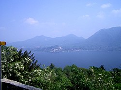
The province of Verbano-Cusio-Ossola (Template:Langx, {{#invoke:IPA|main}}) is a province in the Piedmont region of Italy. It was created in 1992 through the fusion of three geographical areas which had previously been part of the province of Novara. The area flanking the western shore of Verbano (or Lago Maggiore) forms the eastern part of the province; Cusio (or Lago d’Orta) and its environs form the southern part; while the north and west of the province consist of the Ossola, a region of Alpine mountains and valleys. The ISO code for the province is VB.
The province has a total population of some 160,000, distributed over an area of Template:Convert, with the biggest population centres being its capital Verbania on the shores of Lago Maggiore, Domodossola the main town of the Ossola, and Omegna at the northern end of Lago d’Orta.
Municipalities


There are 74 comuni (Template:Singular: comune) in the province.[1] The largest by population are:
| Comune | Population |
|---|---|
| Verbania | 30,836 |
| Domodossola | 18,362 |
| Omegna | 15,949 |
| Gravellona Toce | 7,595 |
| Villadossola | 6,915 |
| Cannobio | 5,113 |
| Stresa | 5,104 |
The full list is:
- Antrona Schieranco
- Anzola d'Ossola
- Arizzano
- Arola
- Aurano
- Baceno
- Bannio Anzino
- Baveno
- Bee
- Belgirate
- Beura-Cardezza
- Bognanco
- Borgomezzavalle
- Brovello-Carpugnino
- Calasca-Castiglione
- Cambiasca
- Cannero Riviera
- Cannobio
- Caprezzo
- Casale Corte Cerro
- Ceppo Morelli
- Cesara
- Cossogno
- Craveggia
- Crevoladossola
- Crodo
- Domodossola
- Druogno
- Formazza
- Germagno
- Ghiffa
- Gignese
- Gravellona Toce
- Gurro
- Intragna
- Loreglia
- Macugnaga
- Madonna del Sasso
- Malesco
- Masera
- Massiola
- Mergozzo
- Miazzina
- Montecrestese
- Montescheno
- Nonio
- Oggebbio
- Omegna
- Ornavasso
- Pallanzeno
- Piedimulera
- Pieve Vergonte
- Premeno
- Premia
- Premosello-Chiovenda
- Quarna Sopra
- Quarna Sotto
- Re
- San Bernardino Verbano
- Santa Maria Maggiore
- Stresa
- Toceno
- Trarego Viggiona
- Trasquera
- Trontano
- Valle Cannobina
- Valstrona
- Vanzone con San Carlo
- Varzo
- Verbania
- Vignone
- Villadossola
- Villette
- Vogogna
Demographics
The top eight countries of origin of the inhabitants of Verbano-Cusio-Ossola with foreign citizenship at 31 December 2010 were:<ref>{{#invoke:citation/CS1|citation |CitationClass=web }}</ref>
- Template:Flagicon Ukraine: 1724
- Template:Flagicon Morocco: 1402
- Template:Flagicon Romania: 1233
- Template:Flagicon Albania: 770
- Template:Flagicon China: 737
- Template:Flagicon Senegal: 429
- Template:Flagicon Germany: 315
- Template:Flagicon Switzerland: 219
Culture
UNESCO Sacred Mountains
In 2003, the Sacred Mountain of Domodossola and the Sacred Mountain of Ghiffa were inserted by UNESCO in the World Heritage List.
-
 Sacro Monte di Domodossola
View of the chapels IX and XI -
 Sacro Monte di Domodossola
Chapel IX -
 Sacro Monte di Domodossola
 -
 Sacro Monte di Ghiffa
Crucifixion and Trinity, 16th century -
 Sacro Monte di Ghiffa
Unknown artist of the 18th century, Three Angels visiting Abraham -
 Sacro Monte di Ghiffa
Landscape from the Sacro Monte


Cuisine
Common in the whole Insubria area are {{#invoke:Lang|lang}}, originating from Alto Milanese, which consist in a braised meat dish cut very thin and cooked in wine and fennel seeds, historically obtained by stripping leftover meat.
.jpg)

.jpg)
Transport

Motorways
The province is crossed by the following motorways (in Italian, autostrade):
Railway lines
See also
Footnotes
References
<references />
External links
- Template:Official website
- Portale del Lago Maggiore - a portal run by the local Trading Chamber
- Official web site for European Sacred Mountains Template:In lang