Amesbury, Massachusetts
{{#invoke:other uses|otheruses}} Template:Use American English Template:Use mdy dates Template:Main other{{#invoke:Infobox|infobox}}Template:Template other{{#invoke:Check for unknown parameters|check|unknown=Template:Main other|preview = Page using [[Template:Template:If empty]] with unknown parameter "_VALUE_"|ignoreblank=y|mapframe_args=y | alt | anthem | anthem_link | area_blank1_acre | area_blank1_dunam | area_blank1_ha | area_blank1_km2 | area_blank1_sq_mi | area_blank1_title | area_blank2_acre | area_blank2_dunam | area_blank2_ha | area_blank2_km2 | area_blank2_sq_mi | area_blank2_title | area_code | area_code_type | area_codes | area_footnotes | area_land_acre | area_land_dunam | area_land_ha | area_land_km2 | area_land_sq_mi | area_metro_acre | area_metro_dunam | area_metro_footnotes | area_metro_ha | area_metro_km2 | area_metro_sq_mi | area_note | area_rank | area_rural_acre | area_rural_dunam | area_rural_footnotes | area_rural_ha | area_rural_km2 | area_rural_sq_mi | area_total_acre | area_total_dunam | area_total_ha | area_total_km2 | area_total_sq_mi | area_urban_acre | area_urban_dunam | area_urban_footnotes | area_urban_ha | area_urban_km2 | area_urban_sq_mi | area_water_acre | area_water_dunam | area_water_ha | area_water_km2 | area_water_percent | area_water_sq_mi | blank_emblem_alt | blank_emblem_link | blank_emblem_size | blank_emblem_type | blank_emblem_sizedefault | blank_emblem_upright | blank_info | blank_info_sec1 | blank_info_sec2 | blank_name | blank_name_sec1 | blank_name_sec2 | blank1_info | blank1_info_sec1 | blank1_info_sec2 | blank1_name | blank1_name_sec1 | blank1_name_sec2 | blank2_info | blank2_info_sec1 | blank2_info_sec2 | blank2_name | blank2_name_sec1 | blank2_name_sec2 | blank3_info | blank3_info_sec1 | blank3_info_sec2 | blank3_name | blank3_name_sec1 | blank3_name_sec2 | blank4_info | blank4_info_sec1 | blank4_info_sec2 | blank4_name | blank4_name_sec1 | blank4_name_sec2 | blank5_info | blank5_info_sec1 | blank5_info_sec2 | blank5_name | blank5_name_sec1 | blank5_name_sec2 | blank6_info | blank6_info_sec1 | blank6_info_sec2 | blank6_name | blank6_name_sec1 | blank6_name_sec2 | blank7_info | blank7_info_sec1 | blank7_info_sec2 | blank7_name | blank7_name_sec1 | blank7_name_sec2 | caption | code1_info | code1_name | code2_info | code2_name | coor_pinpoint | coor_type | coordinates | coordinates_footnotes | demographics_type1 | demographics_type2 | demographics1_footnotes | demographics1_info1 | demographics1_info10 | demographics1_info2 | demographics1_info3 | demographics1_info4 | demographics1_info5 | demographics1_info6 | demographics1_info7 | demographics1_info8 | demographics1_info9 | demographics1_title1 | demographics1_title10 | demographics1_title2 | demographics1_title3 | demographics1_title4 | demographics1_title5 | demographics1_title6 | demographics1_title7 | demographics1_title8 | demographics1_title9 | demographics2_footnotes | demographics2_info1 | demographics2_info10 | demographics2_info2 | demographics2_info3 | demographics2_info4 | demographics2_info5 | demographics2_info6 | demographics2_info7 | demographics2_info8 | demographics2_info9 | demographics2_title1 | demographics2_title10 | demographics2_title2 | demographics2_title3 | demographics2_title4 | demographics2_title5 | demographics2_title6 | demographics2_title7 | demographics2_title8 | demographics2_title9 | dimensions_footnotes | dunam_link | elevation_footnotes | elevation_ft | elevation_link | elevation_m | elevation_max_footnotes | elevation_max_ft | elevation_max_m | elevation_max_point | elevation_max_rank | elevation_min_footnotes | elevation_min_ft | elevation_min_m | elevation_min_point | elevation_min_rank | elevation_point | embed | established_date | established_date1 | established_date2 | established_date3 | established_date4 | established_date5 | established_date6 | established_date7 | established_title | established_title1 | established_title2 | established_title3 | established_title4 | established_title5 | established_title6 | established_title7 | etymology | extinct_date | extinct_title | flag_alt | flag_border | flag_link | flag_size | footnotes | founder | geocode | governing_body | government_footnotes | government_type | government_blank1_title | government_blank1 | government_blank2_title | government_blank2 | government_blank2_title | government_blank3 | government_blank3_title | government_blank3 | government_blank4_title | government_blank4 | government_blank5_title | government_blank5 | government_blank6_title | government_blank6 | grid_name | grid_position | image_alt | image_blank_emblem | image_caption | image_flag | image_map | image_map1 | image_seal | image_shield | image_size | image_skyline | imagesize | image_sizedefault | image_upright | iso_code | leader_name | leader_name1 | leader_name2 | leader_name3 | leader_name4 | leader_name5 | leader_party | leader_title | leader_title1 | leader_title2 | leader_title3 | leader_title4 | leader_title5 | length_km | length_mi | map_alt | map_alt1 | map_caption | map_caption1 | mapsize | mapsize1 | module | motto | motto_link | mottoes | name | named_for | native_name | native_name_lang | nickname | nickname_link | nicknames | official_name | other_name | p1 | p10 | p11 | p12 | p13 | p14 | p15 | p16 | p17 | p18 | p19 | p2 | p20 | p21 | p22 | p23 | p24 | p25 | p26 | p27 | p28 | p29 | p3 | p30 | p31 | p32 | p33 | p34 | p35 | p36 | p37 | p38 | p39 | p4 | p40 | p41 | p42 | p43 | p44 | p45 | p46 | p47 | p48 | p49 | p5 | p50 | p6 | p7 | p8 | p9 | parts | parts_style | parts_type | pop_est_as_of | pop_est_footnotes | population | population_as_of | population_blank1 | population_blank1_footnotes | population_blank1_title | population_blank2 | population_blank2_footnotes | population_blank2_title | population_demonym | population_demonyms | population_density_blank1_km2 | population_density_blank1_sq_mi | population_density_blank2_km2 | population_density_blank2_sq_mi | population_density_km2 | population_density_metro_km2 | population_density_metro_sq_mi | population_density_rank | population_density_rural_km2 | population_density_rural_sq_mi | population_density_sq_mi | population_density_urban_km2 | population_density_urban_sq_mi | population_est | population_footnotes | population_metro | population_metro_footnotes | population_note | population_rank | population_rural | population_rural_footnotes | population_total | population_urban | population_urban_footnotes | postal_code | postal_code_type | postal2_code | postal2_code_type | pushpin_image | pushpin_label | pushpin_label_position | pushpin_map | pushpin_map_alt | pushpin_map_caption | pushpin_map_caption_notsmall | pushpin_map_narrow | pushpin_mapsize | pushpin_outside | pushpin_overlay | pushpin_relief | registration_plate | registration_plate_type | seal_alt | seal_link | seal_size | seal_type | seat | seat_type | seat1 | seat1_type | seat2 | seat2_type | settlement_type | shield_alt | shield_link | shield_size | short_description | subdivision_name | subdivision_name1 | subdivision_name2 | subdivision_name3 | subdivision_name4 | subdivision_name5 | subdivision_name6 | subdivision_type | subdivision_type1 | subdivision_type2 | subdivision_type3 | subdivision_type4 | subdivision_type5 | subdivision_type6 | template_name | timezone | timezone_DST | timezone_link | timezone1 | timezone1_DST | timezone1_location | timezone2 | timezone2_DST | timezone2_location | timezone3 | timezone3_DST | timezone3_location | timezone4 | timezone4_DST | timezone4_location | timezone5 | timezone5_DST | timezone5_location | total_type | translit_lang1 | translit_lang1_info | translit_lang1_info1 | translit_lang1_info2 | translit_lang1_info3 | translit_lang1_info4 | translit_lang1_info5 | translit_lang1_info6 | translit_lang1_type | translit_lang1_type1 | translit_lang1_type2 | translit_lang1_type3 | translit_lang1_type4 | translit_lang1_type5 | translit_lang1_type6 | translit_lang2 | translit_lang2_info | translit_lang2_info1 | translit_lang2_info2 | translit_lang2_info3 | translit_lang2_info4 | translit_lang2_info5 | translit_lang2_info6 | translit_lang2_type | translit_lang2_type1 | translit_lang2_type2 | translit_lang2_type3 | translit_lang2_type4 | translit_lang2_type5 | translit_lang2_type6 | type | unit_pref | utc_offset | utc_offset_DST | utc_offset1 | utc_offset1_DST | utc_offset2 | utc_offset2_DST | utc_offset3 | utc_offset3_DST | utc_offset4 | utc_offset4_DST | utc_offset5 | utc_offset5_DST | website | width_km | width_mi }}{{#invoke:Check for clobbered parameters|check | template = [[Template:Template:If empty]] | cat = Template:Main other | population; population_total | image_size; imagesize | image_alt; alt | image_caption; caption | settlement_type; type | utc_offset1; utc_offset | timezone1; timezone }}{{#if:
|
}}Template:Main other{{#ifexpr:{{#invoke:ParameterCount|main|mapframe|image_map|image_map1|pushpin_map}} >2 |Template:Main other}}
Amesbury is a city in Essex County, Massachusetts, United States, located on the left bank of the Merrimack River near its mouth, upstream from Salisbury and across the river from Newburyport and West Newbury. The population was 17,366 at the 2020 United States census.<ref name="2020_Census">{{#invoke:citation/CS1|citation |CitationClass=web }}</ref> A former farming and mill town, Amesbury is today largely residential. It is one of the two northernmost towns in Massachusetts (the other being neighboring Salisbury).
History
Pre-Colonial Period
At the time of European contact and colonization, the area north of the Merrimack River was inhabited by the Pentucket Tribe of the Pennacook confederation.<ref>Template:Cite book</ref> Several places in Amesbury retain or have been returned to indigenous names including the Powwow River and Hill, and Lake Attitash.<ref>Template:Cite book</ref><ref>Template:Cite book</ref>
Colonial Period
Plantation at Merrimac
In 1637, the first English settler in the Salisbury-Amesbury region, John Bayly, crossed the Merrimack River from the new settlement at Newbury, built a log cabin, and began to clear the land for cultivation. He intended to send for his wife and children in England, but they never joined him.<ref name=":0">Template:Harvnb.</ref> He and his hired man, William Schooler, were arrested for a murder Schooler had committed.<ref name=":0" /> Schooler was hanged for the murder but Bayly was acquitted.<ref name=":0" /> Given the fishing rights on the river by the subsequent settlement, provided he would sell only to it, he abandoned agriculture for fishing.<ref name=":4">Template:Harvnb</ref>
On September 6, 1638, the General Court of Massachusetts created a plantation on behalf of several petitioners from Newbury, on the left bank of the Merrimack, as far north as Hampton, to be called Merrimac.<ref>Template:Cite book</ref><ref>Template:Cite book</ref><ref name=":1">Template:Harvnb.</ref> They were given permission to associate together as a township.<ref name=":1" /> The area remained in possession of the tribes along the Merrimack, who hunted and fished there.<ref name=":1" />
The settlers of the plantation, who entered Massachusetts Bay Colony, were rebels in a cause that was settled by the English Civil War (1642–1651).<ref name=":2">Template:Cite book</ref> Although nominally subjects of the crown, they did not obey it.<ref name=":3">Template:Cite book</ref> The settlers maintained close ties with the Parliamentary cause in Britain.<ref name=":2" /> The supreme government of the colony was the General Court, which functioned autonomously, passing its own laws, establishing courts, incorporating townships and providing for the overall defense of the colony.<ref name=":3" /> They established a Puritan church rather than the Church of England.<ref name=":2" />
In the early spring of 1639, approximately 60 planters took up residence on land cleared by the natives. In May, an elected planning committee laid out the green, the initial streets, the burial ground, and the first division into lots, apportioning the size of a lot to the wealth of the settler.<ref>Template:Harvnb.</ref> In November, the General Court appointed a government of six, which required that every lot owner take up residence on his lot.<ref>Template:Harvnb</ref> They began to assign lots west of the Pow-wow river. The town was originally named Colchester, but was renamed Salisbury in October 1640, potentially at the suggestion of Christopher Batt, from Salisbury, England.<ref name=":4" /> Batt trained the militia in the town.<ref name=":4" /> The incorporation of the town granted it legal recognition by the colony to a township of that name, with its own government, empowered by citizens populating a territory of legally defined boundaries.<ref name=":4" /> The original Salisbury was many times larger than the present. From it several townships were later separated.<ref>Template:Harvnb.</ref>
On January 12, 1641, a town meeting ordered the first roads north and west of the Pow-wow River to be built.<ref name=":5">Template:Harvnb.</ref> On April 21, another meeting granted William Osgood 50 acres of "upland" and 10 of "meadow" along the Pow-wow River, provided he build a sawmill for the town to use. It utilized a water wheel driven by the Pow-wow River.<ref name=":5" /> The mill produced lumber for local use and pipe-staves for export.<ref name=":5" /> A gristmill was added to the Pow-wow river location in 1642.<ref name=":6">Template:Harvnb.</ref> The Powwow River provided water power for a subsequent mill complex.<ref name=":6" /> In 1642, the town wanted families to take up residence west of the Pow-wow and form a "New Town." No volunteers responded.<ref name=":6" />
In 1643, the General Court divided Massachusetts Bay Colony into four counties: Essex, Norfolk, Middlesex and Suffolk.<ref name=":7">Template:Harvnb.</ref> Norfolk contained Salisbury, Hampton, Haverhill, Exeter, Dover, and Strawberry Bank (Portsmouth).<ref name=":7" /> This division was a legal convenience based on the distribution of courts.<ref name=":7" /> Since the first establishment of four courts on March 3, 1635, the General Court had found it necessary to multiply and distribute courts, so that the magistrates would not spend time in travel that they needed for settling case loads. The main requirement for membership in a shire was incorporation.<ref name=":122">Template:Harvnb.</ref>
Separation from Salisbury
Private occupation of the west bank of the Pow-wow River went on as East Salisbury citizens sold their property and moved to New Town.<ref name=":8">Template:Harvnb.</ref> However, New Town remained a paper construct without enforcement.<ref name=":8" /> On January 14, 1654, articles of agreement adopted at town meeting divided Salisbury into Old Town and New Town, each to conduct its own affairs.<ref name=":8" /> The border was the Pow-wow.<ref name=":8" /> The agreement went into effect on January 19, 1655. In New Town, a new government was voted in, which claimed authority over "all matters of publicke concernment."<ref>Template:Harvnb.</ref> They still paid taxes to Old Town and expected services from it. The board of Old Town contained some members from New Town for fair representation.<ref>Template:Harvnb.</ref> This agreement also was known as a "settlement".
On May 26, 1658, New Town petitioned the General Court for independent town status, but the Old Town denied the petition.<ref name=":9">Template:Harvnb.</ref> The Old Town required all inhabitants, including those in the New Town, to attend church in Old Town and fined settlers for each missed meeting<ref name=":9" /> The church and preacher were maintained from taxes.<ref name=":9" /> Minister Joseph Peasley of New Town and his congregation attempting to defy the General Court were summoned into District Court at Ipswich "to answer for their disobedience", were fined there and Peasly was enjoined from preaching.<ref name=":9" /> Another petition for separation was denied in 1660.<ref>Template:Harvnb.</ref>
The burden of attending church several miles away became so great that New Town built a new meeting house and requested the General Court to find a preacher.<ref name=":10">Template:Harvnb</ref> The court yielded to the petition of 1666, granting the "liberty of a township" to New Town.<ref name=":10" /> The town was unofficially incorporated, meaning a government was constituted and officers elected, on June 15.<ref name=":10" /> It was named New Salisbury, but in 1667 the name was changed to Amesbury on the analogy of Amesbury, England, which was next to Salisbury, England.<ref name=":11">Template:Harvnb.</ref> Amesbury was officially granted incorporation under that name on April 29, 1668.<ref name=":11" />
After King Phillips War (1675–1678), an effort by the natives to rid themselves of the colonists, the Royal Province of New Hampshire was created and took away several towns in northern Norfolk shire.<ref name=":122"/><ref>{{#invoke:citation/CS1|citation |CitationClass=web }}</ref> Massachusetts was reduced in size from most of New England to roughly its current borders. The Court dissolved Norfolk Shire, transferring Salisbury and Amesbury to Essex County.<ref name=":122" />
Industrial Era
Beginning as a modest farming community, Amesbury developed a maritime and industrial economy. Shipbuilding, shipping and fishing were also important.<ref>{{#invoke:citation/CS1|citation |CitationClass=web }}</ref><ref name=":13">{{#invoke:citation/CS1|citation |CitationClass=web }}</ref> The ferry across the Merrimack River to Newburyport was a business until the construction of bridges to cross the river.<ref>{{#invoke:citation/CS1|citation |CitationClass=web }}</ref> Newton, New Hampshire, was set off from Amesbury in 1741, when the border between the two colonies was adjusted.<ref>{{#invoke:citation/CS1|citation |CitationClass=web }}</ref><ref name=":14">Template:Harvnb</ref>
In the 19th century, textile mills were built at the falls,<ref name=":13" /> as was a nail-making factory.<ref>Template:Cite book</ref> Beginning around 1800, Amesbury began building carriages,<ref>Template:Harvnb</ref> a trade which evolved into the manufacture of automobile bodies.<ref name=":15">{{#invoke:citation/CS1|citation |CitationClass=web }}</ref> Prominent manufacturers included Walker Body Company, Briggs Carriage Company, and Biddle and Smart.<ref>{{#invoke:citation/CS1|citation |CitationClass=web }}</ref><ref>{{#invoke:citation/CS1|citation |CitationClass=web }}</ref> The industry ended with the Great Depression.<ref name=":15" /> The Merrimac Hat Company was founded in 1856 and became one of the top hat producers in the nation.<ref>{{#invoke:citation/CS1|citation |CitationClass=web }}</ref> Amesbury also produced Hoyt's Buffalo Brand Peanut Butter Kisses.<ref>{{#invoke:citation/CS1|citation |CitationClass=web }}</ref>
In 1876, Merrimac was created out of West Amesbury.<ref>{{#invoke:citation/CS1|citation |CitationClass=web }}</ref><ref>Template:Cite book</ref> In 1886, West Salisbury was annexed to Amesbury, unifying the mill areas on both banks of the Pow-wow River.<ref>Template:Cite book</ref>
Newspapers in the 19th century included the Amesbury Daily News, Merrimac Journal, Morning Courier, Evening Courier, New England Chronicle, Transcript, and the Villager.<ref>Template:Cite book</ref><ref name="bpl-microtext2">{{#invoke:citation/CS1|citation |CitationClass=web }}</ref> Newspapers in the 20th century included the Amesbury Advocate, Amesbury News, Amesbury Times, and Leader.<ref name="bpl-microtext2" />
Twentieth century and beyond
In 1996, the town changed its status to a city, and adopted the mayor and municipal council form of government, although it retained the title "Town of Amesbury", as voters "thought Amesbury was too small and quaint to be a city".<ref name="city-seal2">Template:Cite news</ref> Voters approved a charter amendment in November 2011 changing the city's official name to the "City of Amesbury" and removing references to the old "Town of Amesbury" name.<ref>Template:Cite news</ref> The name change took effect in March 2012.<ref>{{#invoke:citation/CS1|citation |CitationClass=web }}</ref> The city's seal still bears the name "Town of Amesbury", although the City put forth a bill in 2013 to correct the seal with the new name.<ref name="city-seal2" />
The community has several buildings that feature early architecture, particularly in the Federal and Victorian styles.<ref>Template:Cite book</ref> The "Doughboy", a memorial sculpture by Leonard Craske, stands on the front lawn of the Amesbury Middle School.<ref name=":16">{{#invoke:citation/CS1|citation |CitationClass=web }}</ref> It was dedicated November 11, 1929.<ref name=":16" /> Craske is best known as sculptor for the "Fishermens' Memorial" in Gloucester.<ref>{{#invoke:citation/CS1|citation |CitationClass=web
}}</ref> There is also a monument erected to Josiah Bartlett, the first signer of the Declaration of Independence, who was born in Amesbury.<ref>Template:Cite news</ref>
-
 Thomas Macy House Template:Circa
 -
 Mills in 1914
 -

-
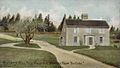
 Whittier's home in 1909


Geography

Amesbury is located at Template:Coord.<ref name="GR1">{{#invoke:citation/CS1|citation |CitationClass=web }}</ref> According to the United States Census Bureau, the city has a total area of Template:Convert, of which Template:Convert is land and Template:Convert, or 10.65%, is water.<ref>{{#invoke:citation/CS1|citation |CitationClass=web }}</ref> Amesbury is drained by the Powwow River. Powwow Hill, elevation Template:Convert, is the highest point in town. Once the site of Indian gatherings, or "powwows", it has views to Maine and Cape Ann. Amesbury is the second northernmost town in Massachusetts, its northernmost point coming just south of the northernmost point of the state, in Salisbury. Amesbury lies along the northern banks of the Merrimack River and is bordered by Salisbury to the east, Newburyport to the southeast, West Newbury to the southwest, Merrimac to the west, and South Hampton, New Hampshire, to the north.
The Powwow River bisects the town, joined by the Back River near the town center. The river flows through Lake Gardner and Tuxbury Pond, which are two of several inland bodies of water in town, including Lake Attitash (which is partially in Merrimac), Meadowbrook Pond, and Pattens Pond. Several brooks also flow through the town. Amesbury has a town forest, which is connected to Woodsom Farm, as well as Powwow Conservation Area, Victoria Batchelder Park and Amesbury Golf & Country Club.
Transportation

Amesbury is served by two interstate highways. Interstate 495 runs from west to east through town, ending at Interstate 95 just over the Salisbury town line. It has two exits in town, Exit 54 at Massachusetts Route 150 (which lies entirely within Amesbury, and leads to New Hampshire Route 150) and Exit 55 at Massachusetts Route 110, which also provides the town's only direct access to Interstate 95 at Exit 58. I-95 crosses the southeast corner of town, entering along the John Greenleaf Whittier Memorial Bridge, a steel through-truss bridge crossing the Merrimack River. The Whittier Memorial Bridge lies just west of the town's only other bridges across the Merrimack, the Derek S. Hines Memorial Bridge, which connects Amesbury to Deer Island (which is still part of Amesbury), and the Chain Bridge, the only suspension bridge in Massachusetts, which spans from Deer Island to Newburyport. The current version was built in 1909, but was predated by the 1810 suspension bridge, one of the oldest suspension bridges in the country. The Chain Bridge and its counterparts over the years have been the main entryways into town across the Merrimack, and until the building of the Newburyport Turnpike Bridge, it was the easternmost bridge on the Merrimack River.
MVRTA provides bus service in Amesbury. Route 51 connects to the Haverhill train station. Route 54 connects to Newburyport train station.
Template:Historical populations
Government
Amesbury is part of the Massachusetts Senate's 1st Essex district.<ref name=Acts2011>Template:Citation</ref>
Demographics


As of the census of 2000, there were 16,450 people, 6,380 households, and 4,229 families residing in the city.<ref name=census2000>Census 2000 Template:Webarchive</ref> The population density was Template:Convert. There were 6,623 housing units at an average density of 206.2 persons/km2 (534.0 persons/sq mi). The racial makeup of the city was 97.2% White, 0.6% African American, 0.22% Native American, 0.9% of the population were Hispanic or Latino of any race.
There were 6,380 households, out of which 34.5% had children under the age of 18 living with them, 51.2% were married couples living together, 11.3% have a woman whose husband does not live with her, and 33.7% were non-families. 26.8% of all households were made up of individuals, and 8.9% had someone living alone who was 65 years of age or older. The average household size was 2.52 and the average family size was 3.09.
In the city, the population was spread out, with 26.1% under the age of 18, 6.1% from 18 to 24, 33.8% from 25 to 44, 22.0% from 45 to 64, and 12.0% who were 65 years of age or older. The median age was 37 years. For every 100 females, there were 93.1 males. For every 100 females age 18 and over, there were 89.7 males.
The median income for a household in the city was $34,906, and the median income for a family was $62,875. Males had a median income of $25,489 versus $31,968 for females. The per capita income for the city was $23,103. 5.9% of the population and 3.9% of families were below the poverty line.
Education
The major educational institutions are:
- Amesbury Public Schools
- SGT. Jordan Shay Memorial Lower Elementary School (K-2)
- Charles C. Cashman Elementary School (3–5)
- Amesbury Middle School (6–8)
- Amesbury High School (9–12)
- Amesbury Innovation High School (School of Choice)
- Sparhawk School (School of Choice)
In 2023, the Amesbury Elementary School closed following the construction of the Shay Memorial School, built on the same property as the Cashman Elementary School. Prior to this, both Amesbury Elementary School and Cashman Elementary School housed K-4 students, with students attending whichever school they lived closer to. Beginning in the 2024-2025 school year, all K-5 students were housed on the same property and divided by age between the Shay Memorial Lower Elementary School and the preexisting Cashman Elementary School.
Amesbury's high school football rival is Newburyport; the two teams play against each other every Thanksgiving Day. The Amesbury mascot is "Red Hawks," formerly the "Indians."<ref>{{#invoke:citation/CS1|citation |CitationClass=web }}</ref><ref>{{#invoke:citation/CS1|citation |CitationClass=web }}</ref>
Public library
As of 2012, the Amesbury Public Library pays for access to information resources produced by Brainfuse, Cengage Learning, EBSCO Industries, LearningExpress, Library Ideas, Mango Languages, NewsBank, Online Computer Library Center (OCLC), ProQuest, TumbleBook Library, World Book of Berkshire Hathaway, and World Trade Press.<ref>{{#invoke:citation/CS1|citation |CitationClass=web }}</ref>
The Public Library houses an extensive Local History and genealogy collection which is open and available for research. <ref>{{#invoke:citation/CS1|citation |CitationClass=web }}</ref>
Points of interest
Notable people
- Jimmy Bannon (1871–1948), outfielder in Major League Baseball<ref>{{#invoke:citation/CS1|citation
|CitationClass=web }}</ref>
- Josiah Bartlett (1729–1795), signer of the Declaration of Independence, fourth Governor of New Hampshire<ref>{{#invoke:citation/CS1|citation
|CitationClass=web }}</ref>
- Daniel Blaisdell (1762–1833), congressman from New Hampshire<ref>{{#invoke:citation/CS1|citation
|CitationClass=web }}</ref>
- Nathaniel Currier (1813–1888), American lithographer, Currier and Ives<ref>{{#invoke:citation/CS1|citation
|CitationClass=web }}</ref>
- Jeffrey Donovan (born 1968), actor; star of television show Burn Notice<ref>{{#invoke:citation/CS1|citation
|CitationClass=web }}</ref>
- Mary Baker Eddy (1821–1910), founder of Christian Science<ref>{{#invoke:citation/CS1|citation
|CitationClass=web }}</ref>
- Robert Frost (1874–1963), poet<ref>Template:Cite book</ref>
- Susannah (North) Martin, victim of Salem witch trials in 1692<ref>{{#invoke:citation/CS1|citation
|CitationClass=web }}</ref>
- William A. Paine (1844–1929), businessman, co-founded the brokerage firm Paine Webber<ref>Template:Cite book</ref>
- Harriet Prescott Spofford (1835–1921), author<ref>{{#invoke:citation/CS1|citation
|CitationClass=web }}</ref>
- Paine Wingate (1739–1838), preacher, served in the Continental Congress; US senator and congressman<ref>{{#invoke:citation/CS1|citation
|CitationClass=web }}</ref>
- Al Capp, cartoonist, author of long running satirical strip Li'l Abner lived in Amesbury for most of his life and is buried in the town.
- John Greenleaf Whittier (1807–1892), poet<ref>{{#invoke:citation/CS1|citation
|CitationClass=web }}</ref>
International relations
Twin towns – Sister cities
Amesbury is twinned with:
- Esabalu, Kenya (since 1987)<ref>{{#invoke:citation/CS1|citation
|CitationClass=web }}</ref>
See also
References
Publications
Books and articles
- Template:Cite book
- Template:Cite book
- Amesbury Vital Records to 1849.Template:Dead link Published 1913. Transcribed and put online by John Slaughter and Jodi Salerno.
- Template:NIE
- Merrill, Joseph, History of Amesbury, from the History of Essex County Volume 2 Chapter 125, pages 1495–1535, compiled by D. Hamilton Hurd, published by J.W. Lewis 1888.
Maps
- Sargeant, Christopher. 1794 Map of Amesbury.
- Clough, Aaron. 1795 Map of Salisbury.
- Nichols, W., J S Morse. 1830 Map of Amesbury.
- Anderson, Philander. 1830 Map of Salisbury.
- Beers, D.G. 1872 Atlas of Essex County, Massachusetts Amesbury. Plate 9. Amesbury and Salisbury Mills. Now Amesbury Center. Plate 12. Salisbury. Plate 15. West Amesbury now Merrimac. And East Salisbury. Plate 17. Salisbury Point. Plate 19. (Now The Point in Amesbury).
- Bigelow, E.H. Amesbury and Salisbury Mills. Bird's-eye view at the Boston Public Library website.
- Norris, George E. Amesbury. Panoramic View. Published 1890. Burleigh Lith. Est. At the Library of Congress website.
- Hughes & Bailey. Amesbury. Panoramic View. Published 1914.
- Walker, George H. 1884 Atlas of Essex County Massachusetts 1884 Map of Amesbury. Plate 169. Amesbury, Salisbury Point. Plate 74. Merrimac Center (was West Amesbury). Plate 151. Amesbury Village Mills. Plate 170-171. 1884 Map of Merrimac. Plate 172. 1884 Map of Salisbury. Plate 175. Salisbury Village Mills on the Powwow River. Plate. 176-177. East Salisbury. Plate 178. Danvers Catholic Church, Folger's Carriage Factory Amesbury. Plate 166.
External links
Template:Essex County, Massachusetts Template:US state navigation box Template:Greater Boston Template:Merrimack River Template:Authority control
- Pages using infobox settlement with the wikidata parameter
- Pages using center with unknown parameters
- Amesbury, Massachusetts
- Cities in Massachusetts
- Populated places established in 1642
- Massachusetts populated places on the Merrimack River
- Cities in Essex County, Massachusetts
- 1642 establishments in the Massachusetts Bay Colony