Astoria–Megler Bridge
Template:Short description Template:Use American English Template:Use mdy dates Template:Main other{{#invoke:Infobox|infobox}}Template:Template other{{#invoke:Check for unknown parameters|check|unknown=Template:Main other|preview=Page using Template:Infobox bridge with unknown parameter "_VALUE_"|ignoreblank=y|mapframe_args=y| also_known_as | alt | aqueduct_name | architect | begin | below | bridge_name | builder | built | capacity | caption | carries | child | clearance | clearance_above | clearance_below | closed | collapsed | complete | contracted_designer | coord_format | coordinates | cost | crosses | dedicated | demolished | depth | design | designer | destroyed | diameter | downstream | electrification | embed | embedded | ends | engineering | extra | fabricator | fetchwikidata | first_diameter | first_length | followed | gauge | height | heritage | id | id_type | image | image_caption | image_size | image_upright | inaugurated | lanes | length | life | load | locale | location | mainspan | maint | maintained | material | material1 | material2 | name | named_for | native_name | native_name_lang | notrack | num_track | number_spans | official_name | onlysourced | open | opened | opening | os_grid_reference | other_name | owner | passable | piers_in_water | pierswater | preceded | qid | rebuilt | references | replaced_by | replaces | second_diameter | second_length | spans | starts | structure_gauge | third_diameter | third_length | toll | towpath | track_gauge | traffic | traversable | upstream | website | width | winner }}Template:Main other
The Astoria–Megler Bridge is a steel cantilever through-truss bridge in the Pacific Northwest region of the United States that spans the lower Columbia River. It carries a section of U.S. Route 101 from Astoria, Oregon, to Point Ellice near Megler, Washington. Opened in 1966, it is the longest continuous truss bridge in North America, and the second-longest in the world.
Lying Template:Convert from the river mouth at the Pacific Ocean, the bridge is Template:Convert in length,<ref name="places">{{#invoke:citation/CS1|citation |CitationClass=web }}</ref> and was the final segment of U.S. Route 101 to be completed between Olympia, Washington, and Los Angeles, California.<ref name="Hobbs">Template:Cite book</ref>
History
Ferry service between Astoria and the Washington side of the Columbia River began in 1926.<ref name=visitor>Astoria–Megler Bridge. Template:Webarchive Astoria & Warrenton Area Chamber of Commerce. Retrieved on May 14, 2008.</ref> The Oregon Department of Transportation purchased the ferry service in 1946.<ref>Template:Cite book</ref> This ferry service did not operate during inclement weather and the half-hour travel time caused delays. In order to allow faster and more reliable crossings near the mouth of the river, a bridge was planned. The bridge was built jointly by the Oregon Department of Transportation and Washington State Department of Transportation.<ref>Template:Cite book</ref><ref>Template:Cite news</ref> Following construction, the Oregon Department of Transportation became the lead agency responsible for maintenance and operating the structure.<ref>Template:Cite journal</ref>
Construction on the structure began on November 5, 1962, and the concrete piers were cast at Tongue Point, Template:Convert upriver. The steel structure was built in segments at Vancouver, Washington, Template:Convert upriver, then barged downstream where hydraulic jacks lifted them into place.<ref name=lalik>Template:Cite news</ref> The bridge opened to traffic on July 29, 1966, marking the completion of U.S. Route 101 and becoming the seventh major bridge built by Oregon in the 1950s–1960s; ferry service ended the night before.<ref>Template:Cite news</ref> On August 27, 1966, Governors Mark Hatfield of Oregon and Dan Evans of Washington dedicated the bridge by cutting a ceremonial ribbon. The four-day ceremony was celebrated by 30,000 attendees who participated in parades, drives, and a marathon boat race from Portland to Astoria.<ref>Template:Cite news</ref> The cost of the project was $24 million, equivalent to $Template:Inflation million in Template:Inflation-year dollars, and was paid for by tolls that were removed on December 24, 1993, more than two years early.<ref name="places"/>
Details

The bridge is Template:Convert in length<ref name=ODOT>{{#invoke:citation/CS1|citation |CitationClass=web }}</ref> and carries one lane of traffic in each direction. The elevated section, which is closest to the Oregon side and composed of three spans, is Template:Convert long,<ref name=ODOT/><ref name=bbehow>Template:Cite news</ref> with the cantilevered central main span measuring Template:Convert.<ref name=structurae>Astoria Bridge. Structurae. Retrieved on July 5, 2015.</ref> It was built to withstand Template:Convert wind gusts and river water speeds of Template:Convert.<ref name="Hobbs"/> As of 2004, an average of 7,100 vehicles per day crossed the bridge.<ref>NBI Structure Number: 07949C009 00241.Template:Dead link Nationalbridges.com. Retrieved on May 14, 2008.</ref> Designed by William Adair Bugge Template:Nowrap construction of the cantilever truss bridge was completed by the DeLong Corporation, the American Bridge Company, and Pomeroy Gerwick.<ref name=structurae/>
The south end has the former toll plaza, at the end of a Template:ConvertTemplate:Cn inclined ramp which forms a spiral bridge, going through a full 360-degree loop while gaining elevation over land to provide almost Template:Convert of clearance over the shipping channel (similarly to the Lincoln Tunnel Helix in Weehawken, New Jersey). The north end is an at-grade intersection with State Route 401. Since most of the northern portion of the bridge is over shallow, non-navigable water, it is low to the water.
Repainting the bridge was planned for May 2009 through 2011 and budgeted at $20 million, to be shared by the states of Oregon and Washington.<ref>{{#invoke:citation/CS1|citation |CitationClass=web }}</ref> A four-year planned paint stripping and repainting project was planned for March 2012 through December 2016.<ref>{{#invoke:citation/CS1|citation |CitationClass=web }}</ref>Template:Needs update inline
In 2016, a colony of double-crested cormorants moved from nearby East Sand Island to the bridge, where they began nesting. Their presence caused issues with bridge inspections, as bird droppings and guano covered visual cracks, and nests obscured navigational lights used by ship traffic. The population of cormorants increased to 5,000 breeding pairs in 2020, prompting efforts by the Army Corps of Engineers to scare the birds from the bridge and relocate them back to East Sand Island.<ref>Template:Cite news</ref>
Pedestrians
Normally, pedestrians are prohibited on the bridge - only motor vehicles and bicycles are allowed.<ref>Oregon Department of Transportation: Oregon Coast Bike Route Template:Webarchive</ref><ref>{{#invoke:citation/CS1|citation |CitationClass=web }}</ref> There is no sidewalk and the shoulders are too narrow for pedestrians adjacent to Template:Convert traffic. However, one day a year—usually in October—the bridge is host to the Great Columbia Crossing.<ref>{{#invoke:citation/CS1|citation |CitationClass=web }}</ref><ref>{{#invoke:citation/CS1|citation |CitationClass=web }}</ref> Participants are taken by shuttle to the Washington side, from where they run or walk to the Oregon side on a Template:Convert route across the bridge. Motor traffic is allowed to use only one lane (of two lanes) and is advised to expect delays during the two-hour event. For the first time, during the 2018 event, the Oregon Department of Transportation announced that the bridge would be closed to motor traffic.<ref>Bridge closure for Great Columbia Crossing: Daily Astorian</ref>
Popular culture
The bridge itself is featured prominently in the movies Short Circuit, Kindergarten Cop, Free Willy 2: The Adventure Home, The Goonies, and Sometimes I Think About Dying. It stands in for the doomed fictional Madison Bridge in Irwin Allen's 1979 made-for-TV disaster movie The Night the Bridge Fell Down.
Images
-
 View of the bridge from Astoria neighborhood
 -
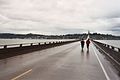
 On the bridge, heading north
 -
 On the bridge, heading north
 -
 Astoria Bridge. Close up view of the through-truss section of the bridge
 -
 A close up view of the through-truss section of the bridge
 -
 A view of the flat, continuous truss section of the bridge
 -
 A workman's view from high on the bridge
 -
 Washington end of the bridge
 -
 A view of the bridge from the Astoria Column
 -
 A cargo ship passing under the bridge
 -
 Looking up from beneath the bridge
 -
 Multiple cargo ships with the bridge in the background
 -
 Bridge at twilight


.jpg)


See also
- Template:Portal-inline
- Template:Portal-inline
- Template:Portal-inline
- Template:Portal-inline
- List of bridges documented by the Historic American Engineering Record in Oregon
- List of bridges documented by the Historic American Engineering Record in Washington (state)
- List of bridges on U.S. Route 101 in Oregon
References
External links
- Pages with broken file links
- Bridges over the Columbia River
- Road bridges in Oregon
- Road bridges in Washington (state)
- Bridges completed in 1966
- Continuous truss bridges in the United States
- Buildings and structures in Astoria, Oregon
- Transportation buildings and structures in Pacific County, Washington
- U.S. Route 101
- 1966 establishments in Oregon
- Former toll bridges in Oregon
- Former toll bridges in Washington (state)
- Historic American Engineering Record in Oregon
- Historic American Engineering Record in Washington (state)
- Bridges of the United States Numbered Highway System
- 1966 establishments in Washington (state)
- Steel bridges in the United States
- Cantilever bridges in the United States
- Transportation buildings and structures in Clatsop County, Oregon